The most beautiful lakes in the French Alps
A mountain lake can be spectacular for almost opposite reasons. At the Chéserys, just a few metres of calm water are enough to turn the Mont-Blanc massif into a mirror. At Serre-Ponçon, by contrast, the vast scale of the reservoir and the shape of its shores build the image. Lac Vert works within a compact woodland setting; Lac d’Annecy, viewed from above, reads as a large, structured landscape; at La Muzelle, the water is just one element in a scene dominated by a hanging glacier.
This selection therefore does not seek to name a universally “most beautiful lake”. It compares sixteen Alpine scenes according to what they actually allow you to photograph: reflection, colour, texture, landscape depth, relationships with a summit, glacier or forest, ease of approach and the main compromise. A well-known lake can remain relevant if its visual signature is irreplaceable; a more discreet place can enter the selection even if the AluArtMountains gallery does not yet hold a photograph matching that exact scene.
The result deliberately differs from a hiking guide. Access information stays at the level needed to choose between a stroll, a moderate hike or a long day at altitude. Detailed routes, GPS information and operational conditions are covered by the Destination guides and official sources. Likewise, reflection technique, polarising filters and exposure settings belong in the Mountain Photography Techniques guides.
Each entry brings a distinct visual signature rather than a place in a ranking.
The right lake depends on the image you want: reflection, colour, broad water, forest or high mountains.
This page helps you choose; the Destination and Techniques guides then take over.
Roads, trails, regulations, snow cover and water levels can change.
How did I select these lakes?
Beauty alone is not enough. To remain in this selection, a lake must offer an identifiable scene: a strong relationship between water and relief, a colour or shoreline texture that truly changes the image, a distinctive foreground, a depth of landscape difficult to find elsewhere, or a seasonal atmosphere that transforms the place. I also sought to avoid repetition. Two lakes in the same massif are not both retained if they tell almost the same photographic story.
I choose the lakes first for their photographic interest, independently of the works available in the gallery. When an AluArtMountains photograph matches the place and scene described exactly, it can illustrate the passage; otherwise, the text stands on its own. La Muzelle is a good example: the combination of lake, vertical cirque and hanging glacier offers a visual language in its own right, even without a matching photograph in the gallery.
Finally, the unit being compared must be honest. For Annecy, the chosen scene is the large lake viewed from the Col de la Forclaz or its viewpoint; for Le Bourget, it is the shore and water facing the Dent du Chat; for Roselend, the reservoir is particularly interesting from views that reveal its shape, the alpine pastures and the hydroelectric structures together. The Vens lakes, meanwhile, are treated as a group: their strength lies precisely in the repetition of water surfaces and waterfalls.
Quick comparison: what image are you looking for?
The table helps shortlist a scene. It gives no scores and is not a ranking.
| Lake | Visual signature | Type of access | Main compromise |
|---|---|---|---|
| Lacs des Chéserys | An intimate mirror of the Mont-Blanc massif | High-altitude hike | Wind and visitor numbers |
| Lac Blanc | A broad, monumental view of Mont-Blanc | High-altitude hike | Very busy and very well known |
| Lac du Crozet | Belledonne’s iconic granite reflection | Moderate hike | Wind |
| Lac Lérié | La Meije and the Girose glacier above a small mirror | High-altitude hike | Wind-exposed plateau |
| Lac Vert de Passy | A compact woodland scene dominated by emerald water | Very easy | Small, busy site |
| Lac d’Allos | Large high-altitude basin, southern palette and larches | Relatively easy access | Access regulated depending on the period |
| Lauvitel | Large natural lake, deep water, forest, rock and changing levels | Moderate hike | Check access |
| Lac Sainte-Anne | Turquoise water below the pale cliffs of the Font Sancte | Moderate hike | Relatively short snow-free window |
| Lac d’Annecy | A broad landscape structured by the lake’s curve from La Forclaz | Very easy from the viewpoint | Well-known, busy scene |
| Lac du Bourget | A minimalist expanse of water facing the Dent du Chat | Very easy from the shores | The scene depends heavily on the atmosphere |
| Lac de Roselend | Turquoise reservoir, dam, alpine pastures and relief | Road to the lake; hike to Roche Parstire | Changing water levels and road conditions |
| Serre-Ponçon | Almost maritime scale, coves and turquoise water | Very accessible | Highly visible water-level fluctuations |
| Lac d’Anterne | A broad horizontal water surface facing the limestone walls of the Fiz | Long hike | Its appeal does not depend on a perfect reflection |
| Lac des Vaches | Stepping stones through the water below the Grande Casse | High-altitude hike | Well-known, busy crossing |
| Lacs de Vens | Several glacial lakes, waterfalls and successive layers | Long hike | Effort and relative remoteness |
| Lac de la Muzelle | Lake, hanging glacier, walls and refuge in one scene | Long, demanding hike | Effort and trail conditions |
Which lake should you choose for your photography project?
For a reflection of a mountain massif, the Chéserys offer a more intimate scene, while Lac Blanc gives greater breadth. Le Crozet replaces the limestone and glaciers of Mont-Blanc with Belledonne’s dark granite. Le Lérié, finally, combines La Meije with a much more open foreground of alpine pastures. In all four cases, the mirror is a possibility dependent on calm water, never a permanent feature.
To make the lake’s colour a true subject, Lac Vert and Sainte-Anne are almost opposites. The first draws its strength from a close woodland setting and an emerald hue; the second from turquoise blue beneath a pale rocky backdrop. Allos adds the palette of the Southern Alps and larches. Lauvitel is less spectacular for colour alone, but richer in its contrast between water, conifers, scree and changing levels.
For a high-mountain scene that tells more than the story of a water surface, La Muzelle offers an especially complete view: hanging glacier, rocky cirque, lake and refuge all belong to the same scene. Lac des Vaches is more graphic thanks to its stepping stones and the Grande Casse. Anterne works through the contrast between horizontal water and great limestone walls. Vens, finally, stands out for a succession of lakes rather than a single basin.
For a woodland atmosphere, Lac Vert is the most immediate choice; Lauvitel offers greater scale and relief. For a very easy outing, Annecy, Le Bourget, Roselend and several locations around Serre-Ponçon offer strong compositions without a long hike. That does not make them “less Alpine”: their photographic interest simply rests on a different relationship between water, landscape and human presence.
Natural lake, modified lake or reservoir: why the distinction sometimes matters
The origin of a body of water creates no aesthetic hierarchy. It is useful only when it explains what we see. Roselend and Serre-Ponçon are reservoirs: their levels can fluctuate considerably, and structures, roads and shorelines contribute to their identity. Le Crozet is a natural lake whose banks were raised historically; this history does not change its character as a high-altitude lake, but explains its present shape. Lauvitel follows a different pattern again: its dam is natural, formed by moraines and material from an ancient rockfall, and changes in level are part of how the site functions.
This distinction helps you choose a scene, not rank places. If the aim is a landscape where human intervention interacts with the mountains, Roselend or Serre-Ponçon make sense. If you are seeking a basin more directly rooted in geology and high mountains, Sainte-Anne, Anterne, Lérié or Muzelle tell a different story.
Mirrors facing mountain massifs
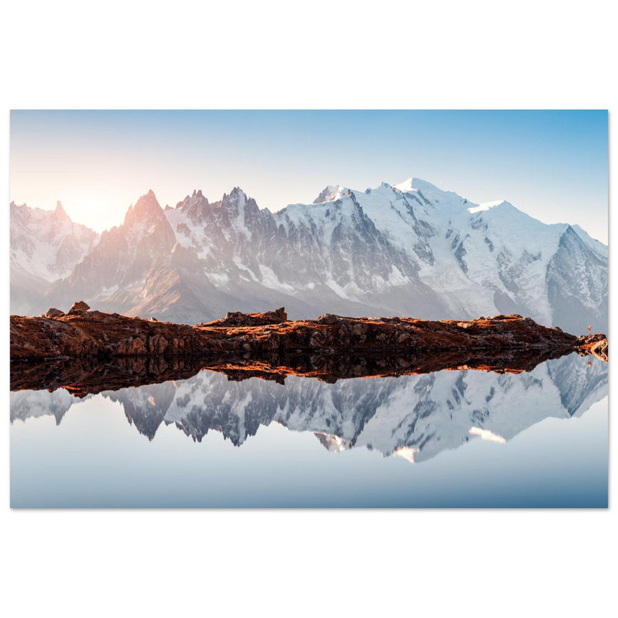
The Chéserys lakes — an intimate mirror of Mont-Blanc
At the Chéserys, the landscape narrows down to a few elements: a small water surface, a rocky or vegetated shore, then the Mont-Blanc massif filling the background. This economy is their strength. The reflection can become very prominent without reducing the photograph to simple symmetry, because the foreground remains close and tangible.
Calm water changes everything. A few ripples are enough to fragment the mountain; conversely, a completely smooth surface turns the summits into a true mirror. The scene is therefore particularly dependent on wind and time of day. That does not call for a specific camera setting in this guide: the first point is to recognise that the reflection is conditional.
Access involves a high-altitude hike, and the area lies within the Aiguilles Rouges nature reserve. Swimming in the lakes is prohibited. To prepare the route or check conditions, the guide to Lac Blanc and the Chéserys lakes and official information take over. The scene associated with this interpretation was photographed first-hand by Pierre Thiaville.

Photograph of Mont-Blanc from the Chéserys lakes at sunset
From the Chéserys lakes in the Aiguilles Rouges, Mont-Blanc glows at sunset: golden reflections, ridges and needles cut into the Chamonix sky.
Photograph: Pierre Thiaville
View the photo print of the Chéserys lakes facing Mont-BlancLac Blanc — breadth rather than intimacy
Lac Blanc shares the same grand backdrop as the Chéserys, but not the same photograph. Here, the Mont-Blanc range is seen on a broader scale. The lakeshore, valley, glaciers and summits create several successive depths. The place therefore accommodates a wider frame, provided the foreground does not absorb everything else.
The reflection can become spectacular when the surface is calm, but it is not the only reason to come. Even without a perfect mirror, the relationship between the two bodies of water and the massif’s great mountain front remains readable. That is precisely what avoids repetition with the Chéserys: one favours proximity, the other monumentality.
The compromise is obvious: the site is very well known and very busy. It too lies in the Aiguilles Rouges nature reserve, with specific protection rules and access dependent on snow cover. The accompanying photograph illustrates this interpretation and remains credited to its photographer.

Photograph of Lac Blanc facing the Mont-Blanc massif
From Lac Blanc, the needles of the Mont-Blanc massif extend into their reflections beneath a hiker’s gaze.
Photograph: Jose Manuel Perez
View the photo print of Lac Blanc facing Mont-BlancLac du Crozet — Belledonne’s granite mirror
Le Crozet changes the material completely. The pale lines of Mont-Blanc give way to dark granite, boulders and the ridges of Belledonne. When the water is calm, the reflection gives an almost symmetrical view of the massif; when the wind rises, the shoreline rocks gain importance and prevent the scene from depending on a single effect.
This alternation makes a useful comparison: the lake remains a strong photographic subject even when conditions do not produce the hoped-for mirror. The composition can then rely on granite boulders, the shoreline or the opening towards the Grésivaudan. The lake is natural, although its banks were historically raised for hydroelectric use.
Access requires a proper hike, but remains moderate compared with the long days at Anterne, Vens or Muzelle. Visitor numbers and wind are the main compromises. For field planning, see Photographing Lac du Crozet in Belledonne. The interpretation offered here is based on a scene photographed first-hand by Pierre Thiaville.

Photograph of reflections on Lac du Crozet in the Belledonne massif
In the heart of Belledonne, Lac du Crozet mirrors the ridges: calm water, granite rocks and late-day light create a graphic, peaceful image.
Photograph: Pierre Thiaville
View the Lac du Crozet in Belledonne photo printLac Lérié — La Meije in an open landscape
Le Lérié stands out for the scale relationship between a small lake and a massif that looks immense without overwhelming the landscape. La Meije, Le Râteau and the Girose glacier rise opposite the Plateau d’Emparis, while alpine pastures leave space around the reflection. The result is less enclosed than at the Chéserys and less rocky than at Le Crozet.
Calm water remains an important condition, as the lake is best known for this mirroring relationship. But the plateau has value in its own right: even with a partial reflection, the horizontal lines of the pastures and La Meije’s silhouette are enough to structure the image. Wind is precisely the main risk for this open scene.
Le Lérié requires a high-altitude hike, with several possible approaches depending on the starting point. Photographing the Plateau d’Emparis is the right guide for planning a specific outing around Lac Lérié. The scene underlying this interpretation was photographed first-hand by Pierre Thiaville.

Photograph of La Meije reflected in Lac Lérié, Plateau d’Emparis, Arves massif
On the Plateau d’Emparis, facing La Meije and Le Râteau, Lac Lérié offers perfect reflections at golden hour and blue hour.
Photograph: Pierre Thiaville
View the photo print of La Meije reflected in Lac LériéColour, forest and texture
Lac Vert de Passy — water as part of the forest’s texture
Lac Vert proves that an Alpine lake scene need not be vast. Here, the photograph is built at close range: emerald water, trunks, boulders, conifers and reflections of vegetation overlap. Distant relief becomes secondary. It is one of the few lakes in this selection where you can almost forget the mountains and work on the texture and depth of the woodland.
Diffuse light, mist or snow strengthen this identity by reducing contrast and simplifying the background. A reflection is possible, but it is not what drives the place. The water’s colour and the density of the forest are more consistent and more specific.
The approach from the Plaine-Joux area is very easy, making the site accessible to a much wider audience than high-altitude lakes. The downside is heavy use within a small space. Swimming is prohibited. The accompanying photograph does show Lac Vert and remains credited to its photographer.

Photograph of Lac Vert below the Fiz massif
Lac Vert reflects fir trees and the cliffs of the Fiz massif in calm, emerald-toned water.
Photograph: Martin Valigursky
View the Lac Vert below the Fiz photo printLac d’Allos — a broad basin in the Southern Alps
Allos brings a different scale: a broad water surface within a rocky cirque, but with light and vegetation characteristic of the Southern Alps. The larches, particularly when they change colour, give the landscape a palette found neither in Belledonne nor in the Aiguilles Rouges.
The lake does not need to be perfectly smooth to work. From the shores or slightly higher viewpoints, the basin remains readable through its shape, repeated rocks and relationship with the Tours du Lac. Autumn can transform the image, but should not become a promise tied to a fixed date: colours and conditions vary from year to year.
The approach can be relatively straightforward when seasonal access is open, but regulations and visitor management in the area can change. Check Parc national du Mercantour information before an outing. The accompanying photograph shows this precise setting and remains credited to its photographer.

Panoramic photograph of Lac d’Allos below the Tours du Lac
Seen from above, Lac d’Allos reveals its islets and blue waters within a broad cirque enclosed by the Tours du Lac.
Photograph: Bruno M Photographie
View the panoramic Lac d’Allos photo printLauvitel — the lake whose level is part of the landscape
Lauvitel is selected not for an iconic reflection, but for the combination of three textures: a broad expanse of dark or blue water, forested slopes descending to the lake and rock walls enclosing the basin. The place changes considerably with the season and especially with the water level, which naturally fluctuates a great deal.
This variation changes the visible shores, boulders, width of the water surface and therefore the available foregrounds. It is not a hydrological detail reserved for specialists: it changes the photograph in concrete terms. This makes Lauvitel very different from Allos or Sainte-Anne, despite all being high-altitude lakes.
Access requires a moderate hike. Some trail conditions in the Vénéon can change quickly: check Écrins National Park information before setting out. The neighbouring strict nature reserve also imposes stringent protection rules. For planning the area, see Photographing Lac du Lauvitel.

Photograph of Lac du Lauvitel in late spring
In late spring, Lac du Lauvitel spreads beneath the last snow patches clinging to the relief of the Écrins massif.
Photograph: Mike Workman
View the Lac du Lauvitel photo printLac Sainte-Anne — colour beneath the Font Sancte
Sainte-Anne is one of the easiest choices to explain visually: clearly defined turquoise water, pale cliffs and the mass of the Font Sancte above the basin. The scene is less wooded than Lac Vert and less vast than Allos. It works through contrasts of colour and texture.
Snow patches can strengthen the rocky character early in the season, while overly harsh light can reduce the water’s nuances. Slightly diffuse light retains the textures of the walls better. Again, the purpose is not to prescribe a camera setting, but to identify what truly changes the place’s appearance.
The hike remains moderate, with an access window dependent on snow cover. The Ceillac area offers other nearby lakes, but Sainte-Anne stands out here for the clear association between turquoise water, the Font Sancte and the rocky setting. To prepare this scene, see Photographing Lac Sainte-Anne in the Queyras.

Photograph of Lac Sainte-Anne below the Font Sancte
Above Ceillac, Lac Sainte-Anne appears as a vast touch of turquoise at the heart of an almost entirely rocky cirque.
Photograph: Christophe Cappelli
View the Lac Sainte-Anne and Font Sancte photo printBroad waters and shaped landscapes
Lac d’Annecy — the geometry of a broad landscape
Lac d’Annecy enters this selection as a broad landscape viewed from La Forclaz rather than simply as a body of water. From this viewpoint, the lake’s curve guides the eye between shores and relief. Water becomes a leading line on the scale of an entire valley, immediately setting it apart from high-altitude lakes photographed from the shore.
Late in the day, light can strengthen volume and depth, but the place does not require a spectacular sunset to work. Its shape remains readable under more neutral light. Stormy conditions or a changing sky can even bring interesting depth between the different layers.
Access to the viewpoint is very easy. This benefits readers looking for a strong scene without a long hike, but also brings a compromise: the site is busy and the general image familiar. The view selected here is specifically from the La Forclaz area, revealing the lake’s overall shape.

Photograph of Lac d’Annecy at sunset
From the Col de la Forclaz, Lac d’Annecy unfolds beneath the warm colours of sunset, between luminous reflections and the relief of Haute-Savoie.
Photograph: Colson Fabrice
View the Lac d’Annecy at sunset photo printLac du Bourget — minimalism facing the Dent du Chat
Le Bourget is especially suited to a stripped-back interpretation. From its shores, the composition can be reduced to a broad water surface, a horizon line and the Dent du Chat. This simplicity works particularly well when mist, cool light or poor visibility erase secondary details.
The photograph then becomes less a demonstration of high mountains than a study of balance between masses. A boat, a shore or a small silhouette can provide enough scale. This language differs greatly from the Annecy panorama: Le Bourget often gains by showing less.
The shores are very easy to reach and allow varied viewpoints without a major undertaking. Choosing a high viewpoint or the Dent du Chat changes the effort completely; this guide does not mix those routes with the main scene selected here, which remains the relationship between shore, water surface and Dent du Chat.

Photograph of Lac du Bourget facing the Dent du Chat
Lac du Bourget stretches out facing the Dent du Chat in a calm, luminous Savoyard landscape.
Photograph: Alina Vaska
View the Lac du Bourget and Dent du Chat photo printLac de Roselend — when the dam becomes a line in the landscape
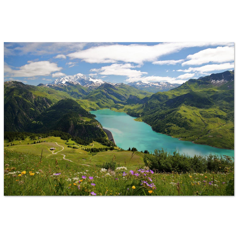
Roselend is a hydroelectric reservoir, and that origin is part of its appeal. Turquoise water, alpine pastures and the dam’s geometry create lines not found in a natural glacial lake. From some viewpoints, Mont-Blanc can enter the composition and add depth.
The water level is decisive: a full reservoir, widely exposed shores or side lighting do not tell the same landscape story. Access roads are also seasonal. Roselend’s photographic interest therefore comes as much from this variability as from its colour.
The lake is easy to approach by road when seasonal access is open; the accompanying view from Roche Parstire, however, requires a hike. The main compromise is the need for up-to-date information: winter access, reservoir level and rules governing use must be checked. Swimming and independent boating are prohibited. From Roche Parstire, the lake is seen within its setting rather than simply as a dam view. For planning, see Photographing the Roselend area.

Photograph of Lac de Roselend and Mont-Blanc from Roche Parstire
From the heights of Roche Parstire, Lac de Roselend stretches through the heart of the Beaufortain, facing the snowy summits of the Mont-Blanc massif.
Photograph: Christophe Cappelli
View the Lac de Roselend from Roche Parstire photo printSerre-Ponçon — a reservoir on an almost maritime scale
Serre-Ponçon takes the idea of large managed waters further still. Its scale, coves and water colour can suggest a maritime landscape, while Alpine relief remains present everywhere. This contrast earns its place in the selection: no other scene combines such a wide water surface with such varied shores.
Water-level fluctuations strongly change the photograph. When the level falls, beaches, banks and shorelines occupy more space; when it is high, coves and a sense of depth dominate. The article should acknowledge this change rather than conceal it behind an ideal, permanent image.
Many viewpoints are accessible without a long hike. The trade-off is heavy summer use and a very wide variety of scenes: choose a precise photographic unit rather than claiming to sum up all of Serre-Ponçon.

Photograph of the turquoise waters of Lac de Serre-Ponçon
The turquoise waters of Lac de Serre-Ponçon wind between rocky shores and the relief of the Southern Alps.
Photograph: Alexandre.ROSA
View the Lac de Serre-Ponçon photo printDistinctive high-altitude scenes
Lac d’Anterne — water facing the Fiz cliffs
Anterne does not need a perfect mirror. Its strength is structural: a broad horizontal surface responds to the pale, vertical walls of the Fiz. The lake becomes a dividing line between alpine pastures and cliffs. A heavy sky or diffuse light can strengthen this contrast rather than weaken it.
This ability to work in less “perfect” conditions sets it apart from reflection scenes. The water can remain dark, the colours restrained and the clouds present: the landscape’s geometry is enough. The relationship between the lake’s horizontal plane and the vertical Fiz gives it an immediately recognisable identity.
Access involves a long hike, and high-altitude weather must be taken seriously. The area is protected and swimming is prohibited. This scene was photographed first-hand by Pierre Thiaville.

Photograph of Lac d’Anterne and the Rochers des Fiz
Lac d’Anterne mirrors the Rochers des Fiz: limestone cliffs, alpine pastures and ridgelines create a graphic, peaceful Alpine scene in the heart of Haute-Savoie.
Photograph: Pierre Thiaville
View the Lac d’Anterne and Rochers des Fiz photo printLac des Vaches — a path through the water below the Grande Casse
Lac des Vaches resembles no other scene in this selection. Its strong image comes from the stepping stones crossing the water and leading the eye towards the Grande Casse. The water almost becomes a graphic support for a human line. Here, the built presence does not compete with the mountain: it provides scale and direction.
The photograph works even without a reflection. Clouds around the Grande Casse or softer light can strengthen depth between the slabs, water and summit. The greater difficulty is visitor numbers: the crossing is well known, and figures can quickly change how the image reads.
Access remains a mountain hike, with possibilities to reduce some of the effort depending on seasonal lift operation. Conditions must be checked before departure, and animals are not permitted on this route. For field planning, see Photographing Lac des Vaches in the Vanoise. The accompanying photograph remains credited to its photographer.

Photograph of Lac des Vaches and the Grande Casse in the Vanoise
Lac des Vaches and its famous stone slabs open a spectacular perspective towards the Grande Casse in the heart of Vanoise National Park.
Photograph: Pete Stuart
View the Lac des Vaches and Grande Casse photo printThe Vens lakes — several lakes making one scene
Vens is best read as a whole. Separating each body of water would lose what makes the place distinctive: glacial lakes, waterfalls, high-altitude meadows and rocks relate to one another on several levels.
This repetition allows composition through depth rather than symmetry. A waterfall can connect two water surfaces; a pale shore can separate layers; late-day light can isolate certain surfaces. The place therefore offers a more complex story than a single lake facing a summit.
Access is long, and relative remoteness is part of the choice. High-altitude conditions, residual snow and trail conditions must be checked. The group stands out above all for this succession of basins and waterfalls, impossible to sum up in a single viewpoint. The accompanying photograph does show the Vens lakes.

Photograph of the Vens lakes at sunset
The Vens lakes glow at sunset amid the wild landscapes of Parc national du Mercantour.
Photograph: BergeImLicht
View the Vens lakes at sunset photo printLac de la Muzelle — the hanging glacier as the main subject
La Muzelle brings a scene found nowhere else in this selection: a lake at the bottom of a cirque, dominated by a hanging glacier and vertical walls, with the refuge as a scale reference.
The lake is therefore not necessarily the dominant subject. It acts as a foreground and breathing space in a landscape where the glacier establishes the vertical dimension. Depending on the light, the contrast between dark water, schist and ice can become more important than the lake’s own colour. A reflection remains a secondary possibility, not the central promise.
Access is long and demanding, and trail conditions can vary. Check Écrins National Park information before an outing. To place La Muzelle within its territory, see Photographing the Vénéon valley. As no gallery photograph matches this scene exactly, I prefer to leave this passage unillustrated rather than show a neighbouring lake or an approximate image.
After choosing: prepare the place, then the technique
This page deliberately stops at the point of choosing. Once you have selected a lake, the Destination guides take over to explore a massif, approach or specific area in depth. The Mountain Photography Techniques guides then address method: creating a readable reflection, deciding whether to use a polariser, managing a wide dynamic range between sky and water, or composing with a close foreground.
This separation avoids repeating the same settings sixteen times and keeps the comparison clear. This guide’s role is to show how the Chéserys differ from Lac Blanc, Roselend from Serre-Ponçon or Sainte-Anne from Lac Vert, then point towards the place best suited to the image you want.
In practice, four reference points sum up the selection: Chéserys or Lérié for a mirror of a massif; Sainte-Anne or Lac Vert for colour; Annecy, Le Bourget, Roselend or Serre-Ponçon for an easy-to-reach scene; Anterne, Vens or Muzelle for a day at altitude where the lake is part of a broader landscape.
Related prints follow the editorial selection, never the reverse. Fifteen scenes correspond to a precise photograph in the gallery; no image is added for La Muzelle because there is no exact match. The gallery thus illustrates the article when it can do so honestly, without dictating the selection.
Official sources and references to check before departure
Access, water levels, regulations and trail conditions can change. The sources below provide references for practical or changeable facts.
- Chéserys lakes — Chamonix
- Lac Blanc — Chamonix
- Lac d’Anterne — Haute-Savoie Tourisme
- Lac Vert — Passy Mont-Blanc
- Lac d’Annecy / La Forclaz — Lac Annecy Tourisme
- Lac du Bourget — Aix Riviera
- Lac du Crozet — Grenoble Tourisme
- Roselend — Arêches-Beaufort
- Lac d’Allos — Parc national du Mercantour
- Plateau d’Emparis / Lac Lérié — Provence-Alpes-Côte d’Azur Tourisme
- Lac des Vaches — Pralognan
- Lauvitel — Écrins National Park
- Lac Sainte-Anne — Guillestrois-Queyras
- Vens lakes — Parc national du Mercantour
- Serre-Ponçon — official website
- Lac de la Muzelle — Écrins National Park
Key takeaways
The sixteen lakes are not sixteen variations of the same mountain waterscape.
Chéserys, Lac Blanc, Crozet and Lérié explore the relationship between water and massif. Lac Vert, Allos, Lauvitel and Sainte-Anne focus more on colour, forest or texture. Annecy, Le Bourget, Roselend and Serre-Ponçon read as broad waters shaping the landscape. Anterne, Lac des Vaches, Vens and Muzelle, finally, tell high-altitude stories in which water is only part of a larger whole.
The best choice is the one that matches the image you want, not the one that tops a ranking.