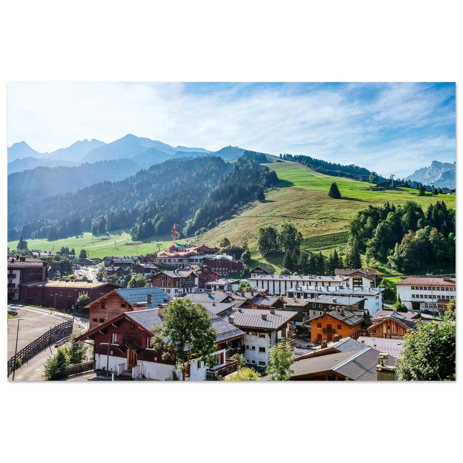
The most beautiful mountain villages in the French Alps
Thirteen villages, thirteen ways of inhabiting the mountains. This selection does not seek a winner: it compares inhabited landscapes in which architecture, settlement pattern and relief remain readable together.
If stone and high altitude come first, Bonneval-sur-Arc offers a particularly clear reference in this selection. For a direct relationship between a village and a great summit, La Grave stands out facing La Meije. Le Grand-Bornand highlights farming, pastoral life and wooden chalets, while Saint-Véran shows how a village sits on a slope. Péone and Saint-Martin-Vésubie open another face of the French Alps, more southern and less dependent on the image of a chalet beneath snow.
The order that follows is therefore not a ranking. It serves only to compare different village forms and choose the one best suited to the landscape you want to discover or photograph.
Thirteen inhabited landscapes selected for different visual reasons.
The selection compares village forms without awarding scores.
Architecture, settlement pattern and mountains must remain readable together.
Skiing, lifts and après-ski are never selection criteria.
How did I select these villages?
A village does not enter this list because it is famous, holds a label or is associated with a ski resort. I selected places where the village itself remains a subject: its buildings are identifiable, its position explains the landscape and its relationship with the mountains brings something the other profiles do not repeat.
Four criteria guide the selection. First, the village’s identity must remain readable in an overall view or in its streets. Next, architecture or morphology must be distinctive enough to carry the image: stone, wood, roofs, density, dispersion or organisation into hamlets. Relief must also maintain a clear relationship with the buildings, without the mountains erasing the village completely. Finally, the selection avoids duplication: two beautiful villages telling exactly the same landscape story do not add twice the value to the comparison.
This method also draws a boundary with resorts. A village may have tourism or a ski area; that is no reason to exclude it. However, pistes, lifts, après-ski and resort identity are never arguments for inclusion here. This selection stays with the inhabited landscape.
To compare the most beautiful ski resorts in the Alps, see the selection devoted to resort landscapes.
Quick comparison: which village should you choose?
The table helps shortlist a village according to its form, relationship with relief and the atmosphere you want. It is not a ranking.
| Village | Territory | Reading the buildings | Relationship with relief | Choose it if… | Keep in mind |
|---|---|---|---|---|---|
| Bonneval-sur-Arc | Haute Maurienne | Dense core of stone and stone-slab roofs | High-altitude valley floor | You seek a very compact old village and a rocky atmosphere | Its strong tourist reputation should not shift the subject towards the resort |
| Bessans | Haute Maurienne | Village and hamlets on a broad level area | Very open inhabited plateau | You prefer a lived-in landscape to a very compact silhouette | The buildings are less uniform, which is part of the village’s identity |
| Saint-Véran | Queyras | Chalets, wood, stone and a bell tower on the slope | Housing stepped up the mountainside | You want to see the village directly contribute to the mountain’s outline | Fame does not replace actual observation of its architecture |
| Névache | Clarée | Grouped rural buildings, stone and larch wood | A village set within a broad valley | You seek a valley village, not just a grand natural backdrop | The Clarée can easily become the main subject if the frame moves too far from the buildings |
| La Grave | Oisans / Écrins | Stone houses and stone roofs | Frontal relationship with La Meije | You seek direct dialogue between village and great summit | Freeride identity and the cable car belong to another reading of the place |
| Besse-en-Oisans | Oisans | Compact village, narrow lanes and stone-paved paths | Present relief without a single dominant summit | Building materials and density interest you more than an iconic panorama | The impact is less immediate than a silhouette facing a great summit |
| Sixt-Fer-à-Cheval | Haut-Giffre | Village centre and network of hamlets | Broad limestone and pastoral enclosure | You want to read the transition between housing, meadows, forests and walls | The Cirque du Fer-à-Cheval can easily absorb the whole story |
| Samoëns | Haut-Giffre | Denser historic centre, stone and hamlets | Valley town surrounded by relief | You want a more structured Alpine town | Some areas are more urban and tourist-oriented |
| Le Grand-Bornand | Bornes-Aravis | Wooden chalets and a farming and pastoral layout | Architecture directly tied to the slopes | You seek a strongly pastoral character | The village must remain the subject despite the resort’s fame |
| Cordon | Mont-Blanc area | Farms and granaries scattered across the hillsides | A balcony village facing great relief | You prefer a dispersed inhabited landscape to a monumental centre | Its appeal comes from dispersion, not a spectacular central silhouette |
| Sainte-Foy-Tarentaise | Haute Tarentaise | A network of hamlets, stone, larch and stone-slab roofs | Settlement spread across the landscape | You are looking for a living village best understood through its several settlements | Distinguish the historic village from the more recent resort |
| Péone | Alpes-Maritimes | A dense centre and old narrow streets | A setting directly beneath rocky landforms | You want to move beyond the classic image of a snow-covered chalet | Valberg is a resort and should not take the place of Péone |
| Saint-Martin-Vésubie | Mercantour | Narrow streets, old houses and a layout shaped by both sides of the Alps | A dense centre set within the valley | You seek a southern Alpine setting with dense buildings and prominent stone | Practical information that may change should be checked separately before a visit |
Choose according to the landscape you seek
For stone, narrow streets and a village defined by its materials
Bonneval-sur-Arc, Besse-en-Oisans, Péone and Saint-Martin-Vésubie offer four very different settings. Bonneval adds high altitude and compactness; Besse-en-Oisans places more emphasis on narrow streets and density; Péone clusters beneath rocky landforms; Saint-Martin-Vésubie has a more southern, transalpine layout.
For a village in direct dialogue with the mountains
La Grave and Saint-Véran are particularly clear examples, but they express two contrasting relationships. In La Grave, La Meije rises directly in front of the village. In Saint-Véran, the buildings themselves follow the slope. Cordon works on a broader scale, with homes scattered across the hillsides, while Névache maintains a gentler relationship with the Clarée valley.
For a pastoral landscape or a scattered village
Bessans, Sixt-Fer-à-Cheval, Le Grand-Bornand, Cordon and Sainte-Foy-Tarentaise show that an Alpine village need not be a tight centre around a church tower. Here, the surrounding land matters as much as the built centre: hamlets, meadows, hillsides and slopes explain how people inhabit the mountains.
For a winter atmosphere
Snow can simplify roof shapes and heighten contrasts, but it does not automatically make a village a better subject. Bonneval-sur-Arc and Saint-Véran suit this approach particularly well because their materials and layout remain legible under snow. La Grave offers a more mineral setting, where the relationship with La Meije can become the dominant feature.
To discover another side of the French Alps
Péone and Saint-Martin-Vésubie keep the selection from being limited to the village types of Savoie and Haute-Savoie. Their appeal does not stem from a need for geographical representation, but from a real visual difference: density, narrow streets, stone and a more southern relationship with the mountains.
Materials shape the image
The groups below simply help organise the discussion. They are neither official categories nor a ranking of villages.
Bonneval-sur-Arc — a compact village where stone remains dominant
Bonneval-sur-Arc works first and foremost through its density. The old village brings together closely packed buildings, stone and stone-slab roofs in a high-altitude setting. This compactness preserves its village identity even when the surrounding mountains occupy a large part of the scene.
The most interesting image need not single out a monument. It can rest on repeated roofs, thick walls and the way the built centre occupies the valley floor. In winter, snow simplifies surfaces without entirely hiding the dark materials.
Bonneval is very well known and also operates as a ski resort. Here, the focus is on the old village, its architecture and its setting.

Stone, stone-slab roofs and snow in the old village
The built centre remains compact and legible beneath the snow, with stone buildings and stone-slab roofs at the heart of the image.
Photography: ventdusud
View the photo print of Bonneval-sur-Arc's old villageBesse-en-Oisans — density rather than a panorama
Besse-en-Oisans offers another way of seeing stone. The village is compact, its streets are narrow, and stone-paved lanes bring the relief into the very layout of its buildings. Mountains surround it, but no single summit is needed to give the place its identity.
It is a good choice if you enjoy images in which materials guide the eye: walls, passages, street lines and changes in height. The village asks for more attention than a spectacular panorama, but that constraint is precisely its appeal. Too wide a frame can dilute the density that sets it apart.
Péone — a southern village closely tied to the mountains
Péone introduces a different character. Its old centre is dense, and the rocky landforms are close enough for the village to feel bound to its mountain without following the visual conventions of the Savoyard chalet.
Up close, the narrow streets and stone can be the subject; from further away, the setting beneath the rocks becomes more important. The place therefore works at two complementary scales. Péone must remain the subject, however: shifting to Valberg would change the focus from village to resort.
Saint-Martin-Vésubie — a transalpine layout in the Mercantour
Saint-Martin-Vésubie adds a more tightly knit layout to this southern character. Its narrow streets, old houses and street channel give the village a structure immediately distinct from those of Haute-Savoie or Savoie.
Its photographic appeal comes less from one spectacular backdrop than from the depth created by streets, façades and glimpses of the mountains. It is a village to explore visually from within as much as from a distance. Access and traffic information may change and need not be fixed here: check it at the time of your visit.
The mountains respond to the village
Saint-Véran — a village built into the slope
In Saint-Véran, the slope is part of the image's architecture. Chalets, roofs and the church tower do not form a horizontal line: they rise in tiers up the hillside. Dark wood, stone and snow can create very clear divisions when conditions simplify the scene.
An overall view needs enough surrounding relief to explain this setting without reducing the houses to a compact strip. In the streets, materials become more important, but a fragment of mountain or the slope itself should still locate the village within its landscape.
Saint-Véran is very well known; its place here rests neither on its label nor on its altitude. It rests on this visual relationship between homes and hillside.

The roofs set the rhythm of Saint-Véran's slope
Snow simplifies the hillside while dark chalets and the church tower keep the village clearly legible.
Photography: Francois Roux
View the photo print of Saint-Véran under snowExplore photography in Saint-Véran and at the Chapelle de Clausis →
Névache — keep the village at the heart of the Clarée
Névache presents an interesting challenge: the Clarée landscape can become so dominant that the village disappears behind the valley's name. To stay with the subject, return to the clustered rural homes, local stone and larch, and show how these elements occupy the valley.
A wide image works if the buildings remain a legible mass rather than an incidental detail. A closer view can instead bring out the materials and structure of the houses. It is all about balance: enough valley to locate Névache, without turning the village into a mere foreground for a natural landscape.
La Grave — the village facing La Meije
La Grave has a particularly direct relationship with its mountains. Stone houses and stone-slab roofs face a mountain that immediately establishes the valley's scale. La Meije can dominate the image without the village having to disappear.
That balance is precisely what holds the subject together. If the frame shows only the face of La Meije, you have moved from photographing the village to photographing the mountain. If buildings fill the frame, the tension between the two is lost. The desired balance lets lights, roofs or terraces give the mountain face a human scale.
Freeride skiing and the cable car are part of the area, but they are not the reason for La Grave's inclusion in this selection.

The village lights give La Meije a sense of scale
The village remains visible and inhabited at dusk while the face of La Meije retains its power.
Photography: Francois Roux
View the photo print of La Grave facing La MeijeExplore photography of La Meije from La Grave →
Cordon — the village as an inhabited balcony
Cordon does not read as a dense centre. Farms and granaries are spread across the hillsides; its appeal lies precisely in that dispersion and in the way homes remain visible against the great mountains.
Avoid trying to impose the silhouette of a village centre that Cordon does not offer. A panoramic view can tell its story better than a single street, provided the buildings do not become a handful of dots lost in the landscape. The village then becomes an inhabited balcony rather than scenery in front of the mountains.
Read the village at the scale of its surrounding land
Bessans — a village opening onto a broad level expanse
Bessans differs from Bonneval-sur-Arc despite their proximity in Haute Maurienne. Where Bonneval relies on the density of its old centre, Bessans spreads into a more open landscape. The village and its hamlets occupy a broad level expanse, completely changing the relationship between buildings and relief.
This openness is an advantage when showing a lived-in landscape: the houses need not form a perfect silhouette to remain the subject. It comes with a less uniform architectural continuity; trying to hide that would erase what truly distinguishes Bessans.
Sixt-Fer-à-Cheval — buildings on the edge of a vast limestone landscape
In Sixt-Fer-à-Cheval, transitions define the village. The centre, hamlets, meadows and forests lead towards much larger rock walls. Its beauty therefore rests not only on a square or street, but on the way homes remain present as nature gradually takes on a greater scale.
The main risk is letting the Cirque du Fer-à-Cheval take over the whole story. A photograph of the cirque or a waterfall can be powerful, but it does not establish the village as the subject. To tell Sixt's story here, buildings, a hamlet or an inhabited transition must remain identifiable.
Samoëns — a more clearly structured centre in the heart of Haut-Giffre
Samoëns offers a denser view of Haut-Giffre. Its historic centre, stone buildings and hamlets give the built environment more weight than in Sixt-Fer-à-Cheval. This structure suits both street scenes and views that place the village back in its mountain surroundings.
This more urban presence calls for greater care in framing. Some compositions may suggest a tourist town more than an inhabited Alpine landscape. Keep a relationship with the valley and the mountains when choosing your shots, rather than simply looking for an attractive façade.
Le Grand-Bornand — agropastoral architecture as landscape
Le Grand-Bornand stands out for the prominence of wooden chalets and their relationship with the slopes and agropastoral activities. Architecture is more than a style here: it reveals how the land is occupied.
A wide view can connect chalets, meadows and mountains, while a closer frame can isolate the wood without entirely losing the hillside context. The resort's fame creates the challenge: as soon as lifts or the ski area become the main feature, the image tells the story of the resort rather than the village.
Explore the photographic landscapes of the Aravis →
Sainte-Foy-Tarentaise — understand the village through its hamlets
Sainte-Foy-Tarentaise cannot be reduced to one central silhouette. The area brings together several hamlets and architecture combining stone, larch and stone-slab roofs. This distribution makes the village interesting as a whole rather than from a single viewpoint.
The frame should therefore show continuity: a few houses on their slope, a sequence of hamlets or a clear relationship between buildings and terrain. The distinction from the resort must remain explicit. The newer resort is a separate subject; here, the historic settlements carry the inhabited landscape.
Photograph a village without losing the mountains
Focal length and viewpoint greatly change the relationship between buildings and relief. A very wide frame can make the mountains spectacular but reduce houses to a detail; too tight a frame can produce an attractive street without explaining where it is. The right distance preserves the village's own character.
In compact villages such as Bonneval-sur-Arc, Besse-en-Oisans or Péone, density and materials can carry the image. In La Grave, Saint-Véran or Cordon, the balance between homes and mountains needs closer attention. In more scattered settlements such as Bessans, Sixt-Fer-à-Cheval or Sainte-Foy-Tarentaise, the issue becomes continuity between buildings, slopes and open spaces.
Detailed settings, exposure management and precise focal-length choices belong in the technical mountain photography guides. Here, the important decision comes first: whether the image should tell the story of the village, the mountains or their relationship.
Explore focal lengths and perspective in the mountains →
Continue exploring the Alps
To explore an area in greater depth, the massif and destination guides take you from this general comparison to more specific subjects. The Queyras guide develops Saint-Véran in particular; the Écrins guide continues from La Grave to La Meije; the Aravis guide details other relationships between inhabited landscapes, Alpine pastures and summits. To go further, head to the most specific guide for the massif or subject rather than multiplying general references.
These thirteen villages are neither an official ranking nor an exhaustive inventory of the French Alps. They are a deliberate selection of inhabited landscapes that tell different mountain stories. Those differences — more than fame — help you choose between a stone lane, a hillside of chalets, a village facing a great summit or a network of hamlets scattered through a valley.
Official and heritage sources
The sources below document the villages' architecture, heritage or identity. Practical information liable to change should always be checked again before travelling.
- Bonneval-sur-Arc — culture and heritage
- Bessans — Auvergne-Rhône-Alpes General Heritage Inventory
- Saint-Véran — Queyras heritage
- Névache — traditional local house
- La Grave — Oisans
- Besse-en-Oisans — heritage village
- Sixt-Fer-à-Cheval — the village
- Samoëns — the village
- Le Grand-Bornand — the chalet as an agropastoral home
- Cordon — traditional homes and hillsides
- Sainte-Foy-Tarentaise — architectural heritage
- Péone — village heritage
- Saint-Martin-Vésubie — architectural heritage
Key points
There is no universally “most beautiful village”. Bonneval-sur-Arc favours mineral density; Bessans, the openness of an inhabited plateau; Saint-Véran, the slope; Névache, the valley; La Grave, its face-to-face relationship with La Meije; Besse-en-Oisans, stone and paved lanes; Sixt-Fer-à-Cheval, the transition to a vast limestone landscape; Samoëns, a more structured centre; Le Grand-Bornand, an agropastoral character; Cordon, an inhabited balcony; Sainte-Foy-Tarentaise, hamlets; Péone, southern mountain forms; and Saint-Martin-Vésubie, a transalpine layout.
The right choice therefore depends on the inhabited landscape you want to explore, not on an absolute ranking.