Ecrins | Photographing La Meije
La Meije is photographed differently depending on the distance between the summit and the photographer. From La Grave, the mountain directly overlooks the valley: the glacial face takes on almost the entire role. From the balcony hamlets, the summit becomes part of an inhabited landscape. Further away or higher up, it becomes possible to place it within a succession of ridges, alpine pastures, and reliefs.
This relationship between La Meije and its context should guide the choice of viewpoint. There isn't one spot to reproduce, but several ways to bring the same subject to life in the image: a large face that imposes its scale, a mountain connected to the valley villages, or a more distant summit that becomes the culmination of a composition.
The Écrins National Park describes La Meije as a major mountain in Oisans and emphasizes how it dominates La Grave. Its north face is largely glacial, giving the subject an immediately recognizable identity: dark rock, ice, ridges, and contrast with the inhabited landscape at the foot of the massif.
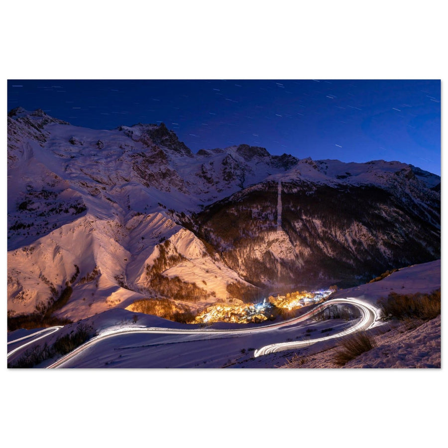
Header photo: Francois Roux — La Grave at dusk facing La Meije.
Reading time: 14 min
The essentials in 30 seconds
- For an image dominated by the mountain, start with a close view from La Grave and greatly simplify the frame.
- To show the scale of La Meije, use the hamlets of La Traverse, heritage buildings, or slope lines as secondary elements.
- Ventelon, Les Terrasses, and Le Chazelet are among the officially documented areas offering views towards La Meije.
- The Col du Lautaret and the Belvédère de l’Homme offer an open view of La Meije, its glaciers, and the Romanche valley.
- Around Villar-d’Arêne, official viewpoints such as Lac du Pontet or l'Aiguillon confirm another relationship between La Meije, the alpine pastures, and the valley.
- Lac du Goléon allows for a distant view through water; a reflection is documented by an official source but remains a possible condition, never a promise.
- The Belvédère Chancel offers an elevated view, but its access and associated services must be checked at the time of the outing.
- A standard focal length maintains the relationship between valley and summit; a longer focal length enhances the presence of the face and allows for isolating the glaciers.
- Light should be treated as a real condition to observe, not a schedule: clouds, clearings, visibility of the face, and rock/ice contrast matter more than a timed promise.
- Francois Roux's photograph shows La Grave at dusk facing La Meije; it illustrates a real scene without defining a universal "best time."
Choosing how to interpret La Meije
La Grave — large face and valley
From La Grave, La Meije has a direct presence. The village is set on a rocky promontory, and the mountain dominates the valley by over two thousand meters, according to the Écrins National Park. This relationship leads to a first simple decision: either the face is almost the exclusive subject, or the village serves as a scale reference.
In a wide composition, avoid accumulating information. A portion of the village, a slope line, or a heritage element may suffice. The more complex the foreground becomes, the more La Meije loses its role. Conversely, a tighter framing allows the mass of the summit, glaciers, and ridges to be used as the main structure.
La Grave therefore functions less as a "backdrop" than as a point of comparison. Human presence immediately makes the mountain's scale perceptible.
Ventelon, Les Terrasses, and Le Chazelet — La Meije in an inhabited landscape
The Park documents Ventelon as a viewpoint overlooking La Meije. It also describes the hamlets of La Traverse — Les Hières, Valfroide, Ventelon, Les Terrasses, and Le Chazelet — located on balconies. Destination Écrins documents views towards La Meije from several of these hamlets.
Photographically, this configuration allows for building the image with successive planes. A hamlet, a hillside, or a line of meadow can occupy the foreground or midground, while La Meije retains the function of a dominant background.
The goal is not to add heritage elements to make the scene picturesque. It is to create a relationship of scale and depth. If the houses become the main subject, La Meije ceases to be the anchor point of the image. If they remain too small to play a role, they become noise. Therefore, look for a clear relationship: a single strong human element, a legible terrain line, then the summit.
The church and cemetery of La Grave are also documented by the Park as allowing for a view of the village with La Meije's glaciers. Here again, the challenge is not to reproduce a precise framing, but to understand that heritage and mountain can work together when each element maintains a function.
Col du Lautaret and Villar-d’Arêne — opening up the landscape
Destination Écrins documents an open landscape from the Col du Lautaret where La Meije dominates other summits. The Belvédère de l’Homme, accessible from this area via an official route, offers views of La Meije, the Lautaret and L'Homme glaciers, and the Romanche valley.
Around Villar-d’Arêne, other official viewpoints further broaden this perspective. Lac du Pontet is documented facing the Écrins summits with La Meije in profile; l'Aiguillon offers a panorama of the valley, La Meije, and Les Agneaux. It is therefore more accurate to speak of the Villar-d’Arêne area than to transform the village itself into a precise spot.
Photographically, these areas are suitable for a more open interpretation: alpine pastures, valley, or relief lines can maintain a real place while La Meije remains the anchor point. A standard focal length preserves this relationship; a longer focal length simplifies the reliefs and reinforces the mountain. No light schedule is deduced from these sources.
Chancel and elevated viewpoints — taking distance
Destination Écrins documents the Belvédère Chancel from the intermediate sector located at 2,400 m. This change in elevation modifies the view: the valley fades more, and the landscape becomes more mineral.
A longer focal length can then be useful for isolating La Meije within the succession of reliefs, reducing secondary elements, and emphasizing the glaciers or ridges. A standard focal length remains relevant if the different planes of the massif truly contribute to the composition.
This type of viewpoint, however, requires different preparation than a view from the valley. Lifts, access, trail conditions, snow cover, and weather change. Therefore, never consider Chancel as a constantly available option: check access, trail conditions, and necessary services at the time of the outing.
Lac du Goléon — interpreting La Meije through water
Destination Écrins documents several routes to Lac du Goléon offering views of La Meije. An official resource dedicated to refuges describes the lake and its refuge facing La Meije and mentions a reflection actually observable in the water.
This relationship allows for a composition where water becomes a foreground or a breath, without the lake becoming the main subject. If a reflection exists, it can enhance the interpretation; if it disappears with wind or light, the shore, the water's texture, or the succession of reliefs remain usable. No specific time or calm water can be guaranteed.
Routes to Goléon remain mountain hikes that require preparation, and conditions must be checked before departure. The presence of a lake facing the summit does not transform access into a simple "photo spot."
The Emparis Plateau also allows for a distant view of La Meije, particularly with the lakes and gentle forms of the plateau. But this landscape has its own photographic logic. Here, it is enough to remember that a greater distance can transform La Meije into an anchor point for a wider landscape; the photography of the plateau and its lakes is developed in the Emparis Plateau guide.
Reading the glacial face
The north face of La Meije is largely glacial, excluding the Grand Pic. The Râteau, Meije, and Tabuchet glaciers are among the features documented by the Écrins National Park.
This material allows for moving away from descriptive landscapes to focus on the mountain itself. With a telephoto lens, a portion of a glacier, a ridge, or a contrast between ice and rock can be enough to build an image. The frame becomes more graphic: fewer elements, more shapes.
The relief is complex. Trying to show everything easily leads to a difficult-to-read photograph. One solution is to choose a single visual tension: the boundary between ice and rock, a ridge crossing the frame, a suspended glacier in a darker area, or a clearing that momentarily highlights part of the summit.
Tight framing does not replace the general view; it addresses a different intention. In the first case, the photograph explains the relationship between La Grave and the mountain. In the second, it makes La Meije an almost abstract subject, constructed by material and volumes.
Composing without losing the subject
A mountain so dominant can paradoxically become secondary in an overly wide photograph. Before shooting, identify the exact role of each plane.
If the village provides scale, limit yourself to a readable portion rather than the entire valley. If a slope guides the eye, let it form a clear diagonal. If clouds separate several planes, use this depth instead of considering them only as an obstacle.
Conversely, if no foreground truly serves the composition, tighten the frame. A longer focal length can eliminate an empty sky, visually bring planes closer, and give more weight to the summit.
Three families of compositions are particularly consistent with the documented geometry of the area:
— dominant mountain: little valley, very present Meije face, a single scale reference;
— inhabited landscape: secondary hamlet or heritage, intermediate slopes, summit in the background;
— distant view: multiple planes of relief or plateau gradually leading towards La Meije.
These families do not correspond to fixed recipes. They allow you to decide what the image tells before choosing the focal length.
Focal lengths: choosing a relationship, not a number
A standard range like 24–70 mm is useful when the photograph needs to maintain multiple planes: village, hillside, valley, and summit. It provides enough context without automatically reducing La Meije to a detail.
A longer range like 70–200 mm becomes interesting when the summit needs to regain prominence or when you want to simplify a complex environment. It also allows for working with glaciers, ridges, and form relationships.
Wide-angle can work if a foreground has an obvious direction towards the mountain. Without this structure, it quickly distances La Meije and adds space without function.
These focal lengths are compositional choices, not inherent data of the location. Adapt them to the actual position, visible relief, and framing intention.
Light, clouds, and visibility of La Meije
No source used for this guide allows for establishing a "best sunrise," "best sunset," or ideal season for each viewpoint. Photography must therefore start from what the light actually does.
When the face is fully visible, observe the separation between rock, ice, and sky. If a clearing only touches part of the mountain, a tight crop can give more strength to that area than the general view. If clouds cling to the summit, they can create depth as long as they leave enough visible structure.
A uniformly empty sky does not need to occupy much space. Conversely, a sky structured by clouds can become a component of the relief.
Francois Roux's work, "Photo de La Grave au crépuscule face à la Meije," demonstrates that a coherent scene exists at dusk from La Grave. It does not transform this period into a universal recommendation. On site, the right choice remains the one that corresponds to the summit's visibility and the scene actually present.
When conditions don't match the plan
Partially obscured summit: wait for a clearing if conditions are stable, or reduce the frame to the still legible reliefs.
Overly busy valley: remove elements rather than trying to organize everything; a longer focal length may suffice.
Empty sky: give more space to the reliefs and inhabited landscape.
Contrasting light: look for a clear area that structures the summit instead of trying to balance the entire massif.
Foreground without function: abandon it. Simplicity is particularly well-suited to such a complex face.
Unavailable high-altitude access: change your approach rather than trying to maintain the initial plan.
Access, commitment, and regulations
La Meije can be observed from very different areas. Views from La Grave and the hamlets do not imply the same commitment as viewpoint hikes, and these are not comparable to high-mountain or mountaineering routes.
For Chancel, the Belvédère de l’Homme, the Lautaret routes, Goléon, and any high-altitude route, check trail conditions, snow cover, weather, and, when necessary, the operation of associated services. Official fact sheets remind that conditions can change and that trail conditions are not constantly monitored.
The La Grave area is located near the heart of the Écrins National Park, but the rules should not be indiscriminately generalized to all viewpoints. Check the exact area of your route and the corresponding regulations before your outing.
A beautiful scene does not justify transforming a hike into a high-mountain route. If the composition requires leaving a safe area or continuing when conditions deteriorate, change your framing.
Works and collections
The photograph of La Grave at dusk shows how the village can remain secondary while La Meije occupies most of the frame.
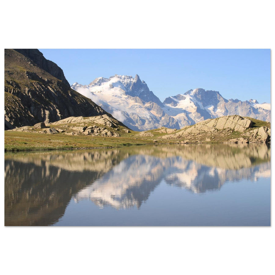
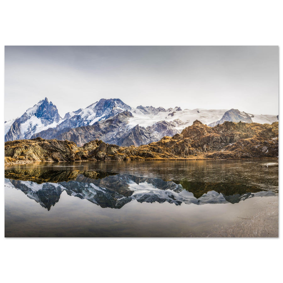
The photograph of Lac Lérié shows a more distant view of La Meije, where the water and plateau fully participate in the composition.

This work illustrates a perspective where the mountain dominates an inhabited landscape.
Photography: Francois RouxView photo print →
This work shows a real reflection scenario and the relationship between water, plateau, and high mountains, without guaranteeing this condition.
Photography: Pierre ThiavilleView photo print →Official sources
- Écrins National Park — La Meije, colossus with feet of clay
- Ecrins National Park — La Grave
- Ecrins National Park Destination — Tour of the hamlets of La Grave
- Ecrins National Park Destination — Belvédère Chancel from 2400m
- Ecrins National Park Destination — Belvédère de l’Homme
- Ecrins National Park Destination — Col du Lautaret to Alpe de Villar-d’Arêne
- Ecrins National Park Destination — Lac du Pontet
- Ecrins National Park Destination — Grande boucle de l’Aiguillon
- Ecrins National Park Destination — Lac du Goléon from Les Terrasses
- Ecrins National Park Destination — Lac du Goléon from Les Hières
- Ecrins National Park Destination — Refuge du Goléon facing La Meije
- Ecrins National Park — Les glaciers de la Meije
Frequently Asked Questions
From which documented areas can La Meije be observed?
La Grave offers the most direct view. The Park and Ecrins Destination also document views from Ventelon, Les Terrasses, Le Chazelet, Col du Lautaret, Belvédère de l'Homme and several areas of Villar-d'Arêne. Lake Goléon provides a more distant view across the water, while Chancel offers a high-altitude perspective. These locations change the distance and context without changing the main subject: La Meije.
How can La Grave or the hamlets be included without losing the mountain?
Use architecture as a reference for scale or as a secondary plane. A part of a village, a bell tower, or a line of houses may suffice. If the human element becomes dominant, narrow the frame or change your position.
Can La Meije be photographed without an alpinism itinerary?
Yes. Several views are documented from the valley, hamlets, and viewpoint trails. However, high-altitude access should be checked according to the weather, snow conditions, and current conditions.
How to choose between a wide shot and a tight crop?
First, decide what the image should show. A wide view is relevant to connect the mountain to the territory. A tight crop is more suitable when the face, glaciers, or a localized area of light become the subject themselves.
What is the best time to shoot?
No universal schedule is established by the sources used. Instead, observe the visibility of the face, the cloud structure, the contrast between rock and ice, and the possible presence of localized light. Prepare several framings to be able to react to the conditions.
What should be checked before going to a high-altitude viewpoint?
The condition of the route, snow cover, weather, and, if necessary, the operation of ski lifts or associated services. This information is volatile and should be checked at the time of your outing.
First choose the distance to La Meije
La Grave and the hamlets provide an inhabited and close-up perspective; more open or distant areas allow for simplifying the face and the planes.