Ecrins | Photographing the Glacier Blanc
The Glacier Blanc is a landscape that unfolds as you advance. From Pré de Madame Carle, the entrance is still through the valley floor, with torrents and forms left by the glaciers. Higher up, the terrain becomes more mineral: polished rocks, moraines, rocky passages, and then an increasing presence of ice and large rock faces.
This progression is what distinguishes the Glacier Blanc from a simple "spot." The subject is not just a tongue of ice. It includes the traces of its passage, the relationship between rock and ice, fractures, seracs, slope breaks, and the scale of the surrounding massif.
The Écrins National Park presents the Glacier Blanc as the longest glacier in the massif and notes that it forms on the north slopes of the Barre des Écrins. It also documents its long-term evolution. For photography, this imposes an essential rule: the landscape must never be treated as a fixed geometry.
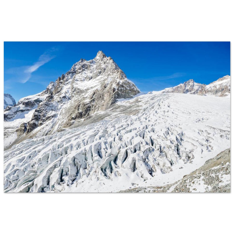
Header photo: Marisa Estivill — Glacier Blanc facing Mont Pelvoux.
Reading time: 12 min
The essentials in 30 seconds
- The Glacier Blanc is a subject of material, scale, and transformation, distinct from the Barre des Écrins.
- Pré de Madame Carle serves as an entry point into the landscape: torrents, moraines, and glacial traces already begin to structure the images.
- As you ascend towards the refuge, the environment gradually becomes rockier and more glacial; photography can follow this transformation.
- A wide shot tells the story of the glacier in its basin; a longer focal length isolates fractures, seracs, snow, and the relationship between rock and ice.
- Polished rocks and moraines are traces of the glacier as much as they are compositional elements.
- Old figures for length, surface area, or front position should not be presented as a current state without a recent date and source.
- Roads, footbridges, paths, and snow cover change: access must be checked with official sources at the time of your trip.
- No glacier progression is necessary or recommended to photograph the Glacier Blanc.
From Pré de Madame Carle to the glacial world
Pré de Madame Carle is documented as a gateway to the Park and as the starting point for glaciers. It is also an important place for understanding the history of the landscape: Glacier Blanc and Glacier Noir still met here at the end of the 19th century.
Photographically, the entrance to the valley allows for working on a more territorial image. The torrents, moraine lines, boulders, and rock faces already show how water and ice have shaped the site.
The main risk is trying to include everything. A glacial valley has many competing lines. Choose one: a torrent crossing the bottom of the frame, a moraine leading towards the top of the valley, a break in the terrain separating two planes. If no foreground plays this role, crop tighter.
The Glacier Blanc doesn't need to occupy the entire image to be the subject, but its presence must remain identifiable. In a very wide shot, ensure the gaze truly reaches the ice and doesn't get lost in the chaos of the foreground.
Polished rocks and moraines: photographing the traces of the glacier
The official route to the refuge passes through rocks polished by glacial erosion. Moraines and former areas uncovered by the glacier's retreat also tell the story of the landscape's evolution.
These forms have a dual photographic value. They provide compositional lines and explain the subject. A moraine can become a diagonal. A polished slab can create a simple foreground. A sharp boundary between dark rock and snow or ice can structure an image without adding decorative elements.
However, avoid turning every geological trace into an autonomous subject. The frame should maintain an overall interpretation: where the ice is located, how the terrain leads to it, and what place the surrounding relief takes in the composition.
The ascent to the refuge: a landscape that changes scale
Destination Écrins documents an ascent with torrent footbridges, polished rocks, crossing the Glacier Blanc torrent, then rocky passages, cables, and ladders higher up.
This description primarily helps understand how the relationship to the landscape changes with altitude. Valley foregrounds gradually disappear; rock and ice become more present; large rock faces take up more space.
This evolution can guide a photographic series. Lower down, prioritize depth and the relationship between water, rock, and the valley. Higher up, simplify. A medium shot can show the ice in its environment; a longer focal length can isolate a fracture, a slope break, or a material contrast.
The Glacier Blanc refuge, located at 2,550 m according to the Park, is a landmark in this environment. The official source indicates that it faces the north faces of Pelvoux, Pic Sans Nom, and Les Ailefroides. These reliefs can provide scale to the glacier, but they should not distract from the subject.
Photographing ice as a material
A glacier is visually complex: snow, bare ice, crevasses, seracs, shadows, and rocks can overlap in the same scene. To avoid an unreadable image, look for structure rather than an accumulation of details.
A fracture line can guide the eye. A change in tone can separate two volumes. A lighter ice area against a dark rock face can be enough to create the main contrast.
With a telephoto lens, the glacier's material can almost become abstract. Photography then no longer seeks to show "all of Glacier Blanc," but an organization of forms: fissures, layers, breaks, and transitions.
In a wider shot, retain enough context for the scale to remain comprehensible. The rock faces, the refuge, or a human presence already on the route can provide this measure, provided they remain secondary and are never staged in an exposed area.
Wide, medium, detail: three ways to tell the story of the same glacier
The wide frame answers a territorial question: in what landscape is the Glacier Blanc situated? It shows the glacial basin, the rock faces, and the valley lines.
The medium frame reduces the number of elements and brings closer the relationship between ice, moraine, and relief. This is often the most balanced format when the environment needs to remain present without dispersing the gaze.
Detail completely changes the intention. A fracture, a serac, or a transition between snow and rock then becomes the main subject. The long focal length allows these forms to be worked from a safe location, without trying to get close to the ice.
These three scales can coexist in a series. They should not be mixed without hierarchy in a single composition.
The Glacier Blanc is an evolving landscape
The National Park has been monitoring the Glacier Blanc for over a century and continues to publish measurement campaigns. This scientific depth is useful for understanding the place: the position of the ice, visible moraines, and even some access points change over time.
An old photograph can therefore show a relationship between glacier and terrain that no longer exists exactly today. This is an additional reason not to give length, surface area, front altitude, or precise position without a date.
For the photographer, this evolution is not just a documentary subject. It influences composition. An old moraine can become a dominant foreground; an area once occupied by ice may now show rock. Good advice must therefore teach how to read the current terrain rather than reproduce a past image.
Light and volume perception
No source used here allows defining a universal time or an optimal season. Ice reacts primarily to the actual contrast present.
Diffuse light can reveal texture nuances without creating very harsh shadows. More directional light can accentuate breaks and volumes. Localized clearings can isolate a portion of the glacier or a rock face and justify a tighter crop.
Watch out for highlights: snow and bright ice can quickly lose detail. The histogram and overexposure warning are more useful than a fixed exposure recipe.
Clouds can also serve depth. A low ceiling that separates several planes can give more relief than a uniform sky. However, do not confuse fresh snow and permanent ice in the interpretation of the scene: what the image shows at one moment does not necessarily describe the lasting state of the glacier.
Focal lengths: choosing the reading scale
A 24–70 mm range is versatile for showing the relationship between glacier, moraine, and rock faces. It is well suited to the landscape's progression and multi-plane compositions.
A longer range, such as 70–200 mm, allows isolating fractures, seracs, overlapping reliefs, and light areas from a safe location.
A wide-angle lens can be useful when the torrent, a moraine, or a nearby rock has a real function in the composition. Without a structuring foreground, it mainly adds space and reduces the presence of ice.
These focal lengths remain compositional options. The terrain and actual position should determine the frame.
Compositions to prepare
Glacier in its basin — ice, rock faces, and valley are hierarchized in a wide frame.
Moraine as a line — a diagonal of rock leads towards the glacier.
Polished rock in the foreground — a simple shape shows the glacial trace without overloading the image.
Ice detail — isolated fractures or seracs from a safe location.
Glacier and rock face — the rock provides scale, the ice remains the subject.
Torrent and glacier — water only works if its direction truly leads towards the ice.
Human scale — a hiker already present can provide a sense of scale for the landscape without being artificially placed for the photo.
When the scene doesn't work
Foreground too busy: remove elements or switch to a longer focal length.
Glacier too small: reduce the context rather than keeping the entire valley.
Ice without structure: look for a fracture, a material boundary, or a tonal break.
Empty sky: reduce its prominence.
Lost highlights: correct exposure before shooting; texture cannot always be recovered afterwards.
Degraded access or missing footbridge: abandon the planned route and consult official information.
Desire to "get closer to the ice": never make this a photographic objective. A long focal length often replaces this need without adding risk.
Access, commitment, and safety
The approach to the Glacier Blanc refuge is a documented mountain hike with elevation gain, footbridges, polished rocks, rocky passages, cables, and ladders. It should not be presented as a simple access to a photo spot.
The dates for installing footbridges, the opening of the road to Pré de Madame Carle, snow cover, and trail conditions vary. After storms or floods, conditions can change rapidly. The floods of 2023 damaged access points, an historical illustration of this terrain's mobility.
Before your outing, consult recent official information. If a passage is reported degraded or if conditions do not match your skill level, turn back.
This page does not recommend any glacier progression. Going onto the ice, roping up, or continuing into mountaineering terrain requires different skills and a different level of commitment than photography from documented hiking trails.
Within the heart of the Écrins National Park, also check the regulations applicable to the exact location.
Works and collections
This photograph shows the Glacier Blanc with Pelvoux as context and relates the glacial material to the large rock faces.

Photo of Glacier Blanc facing Mont Pelvoux
This photograph illustrates an interpretation where ice and large rock faces work together.
Photography: Marisa Estivill
Discover this photo printOfficial sources
- Écrins National Park — The Glacier Blanc
- Écrins National Park — Glacier Blanc, 2026 monitoring
- Écrins National Park — Glacier Blanc Refuge
- Destination Écrins National Park — Glacier Blanc Refuge
- Destination Écrins National Park — From Ailefroide to the Glacier Blanc Refuge
- Écrins National Park — Trail affected by torrential floods
- Écrins National Park — Chalet Refuge du Pré de Madame Carle
Frequently asked questions
Can you photograph the Glacier Blanc without going on the glacier?
Yes. The glacial landscape can be photographed from documented hiking areas and suitable locations. No progression on the ice is necessary to work with moraines, rock faces, textures, or the scale of the glacier.
What do you gradually see between Pré de Madame Carle and the refuge?
The terrain changes from a valley floor structured by torrents and glacial forms to an increasingly rocky and mineral environment. Official sources document polished rocks, footbridges, rocky passages, then a closer glacial environment around the refuge.
How to show the scale of a glacier?
Keep a reference element: wall, moraine, refuge, or naturally present human presence. The element should remain secondary and help the reader understand the dimension of the ice.
Which focal length to use for details?
A long focal length is useful for isolating fractures, seracs, and material relationships without getting close to the glacier. A standard focal length keeps more context around the ice.
Why should access information be rechecked?
Because roads, footbridges, snow cover, and trails change with the seasons, winter damage, storms, and floods. Official sources should be consulted at the time of the outing.
How do I know if my subject is the Glacier Blanc or the Barre des Écrins?
If your image is primarily constructed by the ice material, moraines, fractures, and the evolution of the landscape, the Glacier Blanc is the subject. If the gaze is mainly directed towards the summit, the photographic logic changes: refer to the guide dedicated to the Barre des Écrins.
Read the Glacier Blanc as an evolving landscape
Ice, moraines, polished rocks, and reliefs change scale as you progress: choose the distance that best serves the glacier's material.