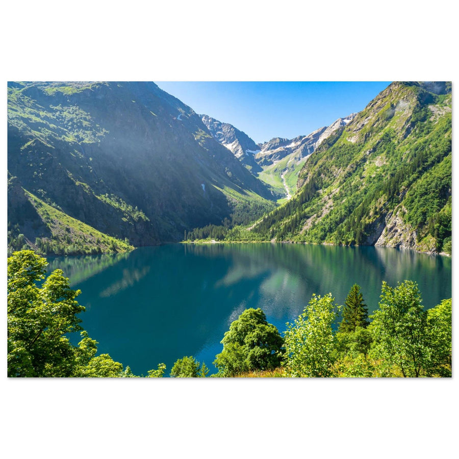
Écrins | Photographing Lac du Lauvitel
Lake Lauvitel operates on a different logic than the grand peaks of the Écrins. Here, water forms the center of the landscape. The slopes that enclose the valley, the forest leading up to it, the rocky shores, and the traces of the landslide that helped form the lake serve to explain this enclosed body of water rather than compete with it.
It's tempting to build the entire outing around a reflection. However, this would reduce the location to a condition that is never guaranteed. Lauvitel can work with perfectly calm water, but also with ripples, color variations, a strong shoreline, or a tighter composition focusing on the relationship between water and relief.
The conservation context is as important as the framing. The lake is located in the heart of the Écrins National Park, and upstream of the lake, the Lauvitel integral reserve is a scientific area closed to the public. Therefore, photographing the site means staying in authorized areas and accepting that a "different" viewpoint has no value if it requires crossing a protection boundary.
Header photo: Mike Workman — Lake Lauvitel in late spring.
Reading time: 13 min
Key points in 30 seconds
- The subject is the lake: the water must remain legible as the anchor point of the image.
- The slopes, forest, shores, and landslide provide depth and structure without becoming competing subjects.
- A reflection is a possibility linked to the state of the water, never a promise.
- If the surface is rippled, use the texture, water colors, a shoreline, or a tighter crop.
- A standard focal length easily maintains the relationship between water and relief; a longer focal length allows isolating a portion of the shore or mountain planes.
- Mike Workman's photograph shows Lauvitel in late spring with visible snow, without establishing an optimal season or guaranteeing the presence of snow at the same time in another year.
- The Oisans fact sheets updated in July 2026 currently indicate a ban on the left bank via Les Gauchoirs until further notice and access to the lake via the right bank. It is essential to check the situation before your outing.
- The integral reserve located upstream is closed to the public: it is not an extension of the shooting area.
Making the lake the anchor point
In a confined valley, the slopes can take up a lot of space in the frame. The first choice is therefore to decide what proportion to give to the water.
If the lake becomes a narrow strip at the bottom of the image, the photograph can shift towards a mountain landscape where Lauvitel is just one element. Conversely, if the water fills almost the entire frame without structure, the image may lack depth.
Look for a relationship. A shoreline can guide the eye. A dark slope can close off one side of the frame. A patch of snow or lighter rock can create a second point of interest. The water then remains the surface that organizes these elements.
Simplicity is particularly effective here. A shoreline, a body of water, and two planes of relief are often enough to explain the place without multiplying details.
Shores, forest, and landslide: structuring the landscape
The official itinerary crosses a landscape where the forest precedes the opening towards the lake. Oisans Tourisme also describes the passage over the landslide that led to the formation of the lake.
These elements can enrich the photograph without requiring a specific point to be sought off the path. The forest can serve as a transition in a series of images. Blocks and rock formations can provide scale at the edge of the lake. A curved or oblique shoreline can serve as a leading line.
Avoid trampling a fragile bank simply to find a more spectacular foreground. A minimal shift in an authorized area or a different focal length is often enough to simplify a too-cluttered shoreline.
The composition must remain compatible with actually authorized access. A visually interesting shoreline is not a goal if it is located in a closed area or if its access requires leaving the permitted route.
Reflection or rippled water: two different images
A reflection does not depend solely on framing. It requires a sufficiently calm surface to reproduce the relief. No retained source confirms that a particular time guarantees this condition.
If a mirror appears, consciously choose the horizon line. A nearly central symmetry can work when the reflection is complete and legible. An off-center composition can be stronger if the shore or a slope has more character.
If the water is moving, abandon the idea of a perfect mirror. Ripples can create bands of light, simplify colors, or break the reflection into more abstract shapes. A longer focal length also allows isolating a portion of the surface or a relationship between water and shore without relying on symmetry.
A polarizing filter can reduce reflections depending on the shooting angle. Check its effect in the viewfinder rather than using it automatically: at Lauvitel, removing a reflection can go exactly against the intended purpose.
Reading an enclosed lake
Lauvitel is not a body of water set in an open space. The slopes directly surround the scene and influence how the lake is perceived.
In a wide frame, use this enclosure to create a sense of depth: water in the foreground, intermediate shore or slope, relief in the background. If both sides of the valley create too much weight, reduce the frame and choose a single slope as a visual boundary.
A longer focal length can also bring planes closer and extract simple relationships: a bright area on a slope above a dark band of water, a rocky shore in front of a still-snowy slope, or a succession of textures between forest, rock, and water.
The goal is not to document every visible peak. The relief serves the lake; it doesn't need to be fully named to work photographically.
Late spring: a possible scene, not a rule
Mike Workman's photograph shows Lake Lauvitel in late spring with patches of snow still present on the slopes.
This scene does not allow us to conclude that late spring is the best period, nor that the snow or access conditions will be identical in another year.
If snow is visible, it can strengthen the contrast with the water and rock. If it has disappeared, build the image with the forms actually present.
Light and contrasts
The retained sources establish neither precise solar orientation nor best time. The framing must therefore adapt to the light actually present in the valley.
Diffuse light can homogenize the slopes and make the water colors more legible. A localized clear patch can create a strong contrast between an illuminated slope and the rest of the valley. In this case, a tighter crop can give more weight to this area.
If the sky is empty, reduce its place. If clouds separate the planes, they can, on the contrary, enhance depth. Also watch out for highlights when snow or very bright areas are present above the lake.
The state of the water remains independent of the quality of the sky. Interesting light with a rough lake simply leads to a different photograph than a perfect reflection.
Focal lengths: balancing water and relief
A 24–70 mm type range is versatile for keeping the lake as the main surface while retaining the slopes and a portion of the shore.
A wide-angle can be useful if a nearby shore or rock creates real depth. Without a structuring foreground, it risks mainly adding space and reducing the weight of the lake.
A 70–200 mm type range allows isolating light, a shore area, water texture, or several layers of relief. It also offers a solution when the foreground is cluttered or inaccessible.
These focal lengths are compositional choices and not prescriptions specific to the location.
Compositions to prepare
Enclosed lake — large body of water, slopes used as a natural frame.
Diagonal shore — the line leads towards the center or the back of the lake from an authorized area.
Full reflection — symmetry used only if the surface truly allows it.
Partial reflection — a portion of mountain or light is sufficient without seeking an integral mirror.
Rippled water — texture and light bands become the secondary subject.
Snow and water — contrast exploited only when snow is actually present.
Telephoto lens — a simple relationship between shore, water, and slope replaces an overly busy panorama.
When the scene doesn't match the plan
No reflection: work with the texture of the water, a shoreline, or a tighter crop.
Inaccessible foreground: do not try to bypass a closure; change focal length or composition.
Too much relief around the lake: choose a single dominant slope or reduce the field of view.
Uninteresting sky: give more space to the water and slopes.
No snow: do not try to reproduce an old image; use the forms actually present.
Access closed or uncertain: abandon the planned itinerary and consult official information.
Reserve boundary: never cross it to get a shot.
Access to Lauvitel: check the situation before each outing
Oisans Tourisme fact sheets, updated on July 2 and 17, 2026, indicate that due to a residual risk of rockfalls, access via the left bank and Les Gauchoirs remains prohibited to all users until further notice. They currently indicate access to the lake via the right bank.
This information is dated. It must be checked before each outing, as an order or terrain conditions may change. Therefore, never consider an old GPS track, a hiking report, or a photograph as proof that a passage is currently authorized.
The same Oisans fact sheets currently indicate that dogs are prohibited, even on a leash, on the documented itinerary. This rule must also be checked at the time of the outing.
Hiking remains a mountain outing with elevation gain and natural terrain. Weather conditions, snow cover, and the condition of the path must be included in the preparation.
Integral reserve: a clear limit for photography
The Lauvitel Integral Reserve was created in 1995 in the heart of the Écrins National Park. The Park specifies that it is intended for the scientific monitoring of natural dynamics little subjected to human action.
It is located at the bottom of the valley, upstream of the lake. Access to it is prohibited to the public; any entry is subject to authorization within the framework provided by the Park.
For a photographer, the consequence is simple: the reserve is not a "wilder area" where to seek a viewpoint. It must remain outside the public shooting area. Therefore, stay in the authorized areas and itineraries around the lake.
Bivouac near the lake
Bivouac regulations changed in 2026. The National Park indicates that, on the shores of Lake Lauvitel and Lake Muzelle, bivouacking is prohibited within 500 m of the lake shore, except in dedicated areas delimited by signage on site.
This rule must be checked before spending a night there. It particularly means that a photographer cannot freely choose any shore to pitch a tent under the pretext of preparing an image early or late in the day.
Respect the indicated areas, signage, and Park rules. If a composition requires setting up outside the authorized area, change your plan.
Artwork and collections
This photograph documents the lake with snow still visible on the slopes. It remains a dated scene and should not be used to promise identical conditions at another time.

Photo of Lake Lauvitel in late spring
This photograph documents the lake with snow still visible on the slopes, without promising identical conditions another year.
Photograph: Mike Workman
Discover this photo printDiscover photo prints of the Écrins mountain range and National Park
Official sources
- Oisans Tourisme — Lac du Lauvitel Hike, updated July 17, 2026
- Oisans Tourisme — Lauvitel starting from Venosc, updated July 2, 2026
- Écrins National Park — The Integral Reserve
- Écrins National Park — Lauvitel Integral Reserve
- Écrins National Park — FAQ
- Écrins National Park — Bivouac regulations are evolving
- Destination Écrins National Park — Lake Lauvitel
Frequently asked questions
What access is currently indicated to reach Lake Lauvitel?
Oisans fact sheets updated in July 2026 indicate access to the lake via the right bank and maintain the prohibition of the left bank via Les Gauchoirs until further notice. This situation must be checked before your outing.
Can Lauvitel be photographed without a reflection?
Yes. A shoreline, the texture of the water, the slopes, the forest, or a tighter crop can be enough to build an image. Reflection is a conditional possibility, not an obligation.
Is the Lauvitel integral reserve accessible to photographers?
No, not to the public. The National Park specifies that access to the integral reserve is prohibited and that any entry falls under an authorization regime. It should not be treated as an extension of the public area of the lake.
Are dogs allowed on the trail?
The Oisans fact sheets, updated in July 2026, currently state that dogs are prohibited, even on a leash, on the documented route. Please check the rules at the time of your visit.
Can we bivouac near the lake?
The 2026 regulations prohibit bivouacking within 500 m of the edge of Lauvitel, except in dedicated areas marked on site. Always check the current rules and signage before spending a night there.
Is late spring the best time to photograph the lake?
No retained source confirms this. Mike Workman's photograph shows a scene with residual snow in late spring. Conditions vary from year to year.
Building the image around Lake Lauvitel
Water remains the anchor point; banks, forest, and slopes serve the composition in the areas actually authorized at the time of the outing.