Beaufortain | Photographing the Saint-Guérin area
Saint-Guérin invites a different way of looking at the Beaufortain. Here, the interest doesn't come from a vast panorama, but from a more compact landscape where four elements interact: the lake, the dam, the shores, and the footbridge. The reservoir provides the main mass, the dam traces a very clear built line, the shores organize depth, and the footbridge introduces an immediately legible diagonal.
This proximity of shapes makes the site particularly interesting for working on composition. It is not necessary to show everything. An image can be built around a shoreline curve, a portion of the dam, or the footbridge above the water. A wider view then allows these elements to be placed back within the Beaufortain's mountain pastures and relief.
The official route connects the dam, the East shore, and the footbridge. This allows for building a progressive series without relying on a long hike. The difficulty lies elsewhere: as the elements are close and immediately identifiable, framing can quickly become repetitive if one doesn't clearly decide what should carry the image.
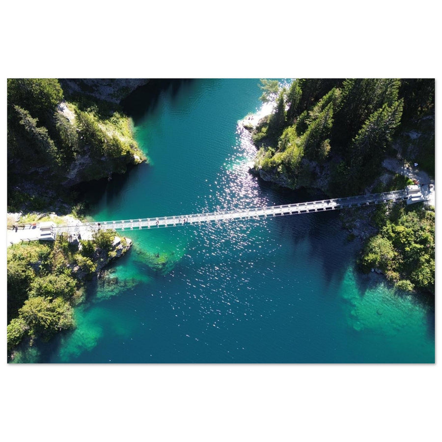
Header photo: laetom_drone — aerial view of Lac de Saint-Guérin in the Beaufortain.
The essentials in 30 seconds
- A compact system: lake, dam, shores, and footbridge form a single photographic subject.
- Site scale: the Tourist Office places the lake at around 1,557 m; the reservoir covers 50 ha and the dam measures approximately 250 m long.
- Route: the official itinerary starts from the car park, reaches the dam, follows the East shore, then leads to the footbridge.
- Lake: a reflection is neither guaranteed nor necessary; the shores and contrasts can be enough to structure the image.
- Dam: its curve can become the strong line of the frame, provided a legible relationship with the landscape is maintained.
- Footbridge: it functions as a diagonal or a scale reference, without needing to be centered.
- Drone: existing aerial photographs never constitute a general flight authorization.
Understanding the Saint-Guérin system
The Arêches-Beaufort Tourist Office places Lac de Saint-Guérin at around 1,557 meters altitude. The reservoir covers 50 hectares, and the thin arch dam measures approximately 250 meters long. The discovery trail also includes a Himalayan footbridge with an 83-meter span, suspended more than 20 meters above the gorge.
These figures primarily serve to understand the scale. Photographically, the interest comes from the relationship between shapes. The dam is not just a structure: its curve can become a leading line. The footbridge is not just a crossing point: it can function as a diagonal or a scale reference. The lake is not just a blue surface: it can be reduced to a band of color or become the main plane.
Saint-Guérin therefore functions as a graphic system. A photograph benefits from being thought of less as "a view of the lake" and more as an organization of shapes in a confined space.
The first question is not "where is the best viewpoint?", but "which element should carry the image?". Moving around the site then serves to modify the relationship between water, structure, and relief.
Choosing the dominant element
Three main approaches allow for real variety in a series.
| Approach | Dominant element | Role of other elements | When to simplify |
|---|---|---|---|
| The dominant lake | Water and shore | Dam or footbridge provide scale | Reduce water if it becomes a uniform surface |
| The dam as a strong line | Curve of the structure | Shore and relief maintain the mountain context | Tighten if the dam disappears in too wide a panorama |
| The footbridge as an accent | Suspended diagonal | Lake and terrain provide depth and scale | Shift the frame if the footbridge awkwardly cuts the rest of the scene |
These approaches are complementary, not mandatory. The goal is to prevent the lake, dam, and footbridge from demanding exactly the same attention in every image.
Reading the site from the official route
The Savoyard Discovery Walk starts from the Saint-Guérin car park. The route descends to the dam, then follows the lake along its East shore, passes the water intake, and finally reaches the footbridge. This progression is interesting because it gradually changes the relationship between construction, water, and relief.
Near the dam, the structure naturally takes on more weight. As you move along the shore, the water and terrain become dominant again. Approaching the footbridge, the geometry changes once more: the suspended structure introduces a delicate, human-made line into a landscape of reservoir and mountain pastures.
Therefore, it is not necessary to search for a single point that summarizes all of Saint-Guérin. The site is better understood as a succession of positions. With each movement, check what has actually changed: proportion of water, placement of the dam, relationship between footbridge and shore, presence or absence of identifiable relief.
Practical conditions vary. Road conditions, shuttles, equipment opening hours, and visitor numbers should be checked before departure. Opening information displayed on a given date does not constitute a permanent guarantee.
Photographing the lake and its shores
The lake is the most obvious component of the site, but it should not automatically occupy the majority of the frame. A large body of water without direction can quickly weaken the image. The shore then becomes the primary structure: a curve, a change in material, a vegetation line, or a contrast between water and land.
When the shore is clear, it can lead towards the dam or the footbridge. If it becomes confusing, a tighter framing is often more effective. The objective is not to show the entire reservoir, but to retain only the elements that contribute to the reading.
The water's color varies with the sky, light, and shooting angle. Neither guaranteed turquoise nor guaranteed reflection exists. Dark water can enhance the contrast with the mountain pastures; a lighter surface can provide more lightness. The right decision depends on the actual scene.
The reflection should remain a tool, not an imposed objective. If it appears and structures the image, use it. If it is fragmented or absent, a shore or a color difference can very well convey depth.
Using the dam as a strong line
The Saint-Guérin dam has a sufficiently pronounced curved shape to become the backbone of a composition. It can cut the frame, close it, or serve as a transition between the water and the slopes.
Too frontal a framing risks reducing the structure to a simple bar. A slight offset, or the presence of a shore that echoes the dam's curve, maintains more depth. Conversely, if the dam is to be the subject, it must be given enough space for its shape to be legible.
A very tight framing can transform the image into an almost abstract study of concrete, water, and land. This approach is valid if it is deliberate. To maintain a landscape reading of the Beaufortain, keep at least one clue of the site: shore, water, slope, or mountain pasture.
The essential question remains hierarchy. If the dam is merely a landmark, it can remain small. If it carries the image, the lake and relief must accept a secondary role.
Integrating the footbridge without it overwhelming the image
The Himalayan footbridge is one of the most immediately recognizable elements of the site. Its span and height give it a strong presence even when it occupies only a small part of the frame.
The main risk is treating it as an independent object. Placed in the center without relation to other lines, it can become a mere spectacular element. It gains interest when it extends a shore, crosses a visible void, or connects two parts of the terrain.
A human silhouette can provide scale, but it should not be staged to the detriment of other visitors. The site remains a walking area: photography does not justify blocking the path or turning other people's crossings into a shooting setup.
In a wide view, the footbridge can become a detail discovered after the lake. In a tight view, it can structure almost the entire image. Both approaches work if its relation to the terrain remains clear.
Reading Saint-Guérin from aerial views
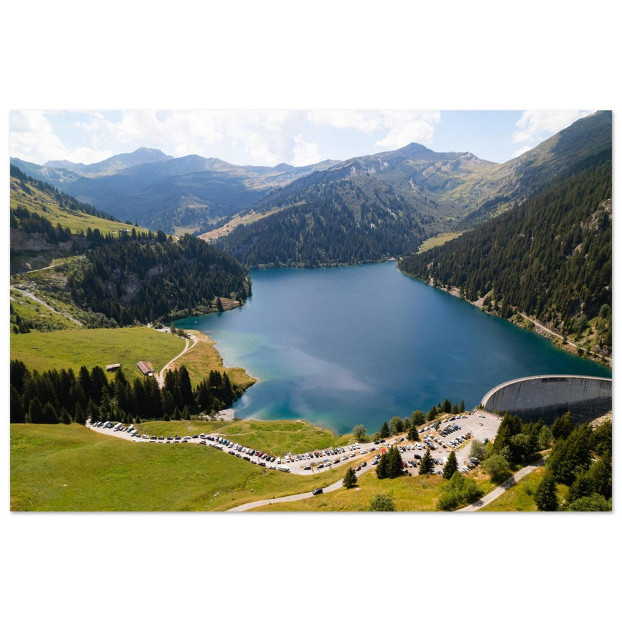
Two photographs currently published in the gallery show Saint-Guérin from the air. They highlight what is less immediately apparent on the ground: the general shape of the reservoir, the curve of the dam, and how the slopes frame the water.
This reading does not mean that a drone is necessary. On the ground, the same compositional questions exist: shoreline curve, dam line, relationship between water and relief. Aerial views here serve to understand the general geometry of the site.
An aerial view can become very abstract if it only retains water and a portion of a structure. To maintain a landscape reading, keep a sufficiently identifiable slope, shore, or mass of relief. If the objective is intentionally abstract, this loss of context must be accepted.

Lac and Barrage de Saint-Guérin
The aerial view immediately reveals the dam's curve and its relationship with the reservoir and the Beaufortain slopes.
Photograph: Sylvain Felten
Discover the Lac and Barrage de Saint-Guérin printThe presence of aerial photographs in the catalog never constitutes a current flight authorization. The exact area, temporary restrictions, people present, wildlife, and local rules must be checked before each takeoff.
Adapting composition to light conditions
Saint-Guérin does not have a universal "best time." Nearby slopes can cast part of the lake in shadow while another part remains illuminated. Cloud cover, the date, and the photographer's position also alter the water's color and the separation of relief.
Instead, prepare two framing scales. A wide view works when water, shores, and slopes separate well. A tighter view becomes useful when the sky adds nothing, when the contrast is too strong, or when a specific portion of the dam or footbridge receives more legible light.
Harsh light does not forbid photography. It can produce graphic shapes if shadows remain usable. Diffused light is not automatically superior either: it can reduce the differences between water, concrete, and vegetation. The intention should guide the choice.
The site therefore particularly lends itself to adaptation. If conditions do not serve a general view, simplify rather than waiting for a theoretical light.
Wide-angle, standard, or telephoto
It is more useful to think in terms of framing families than imposed focal lengths.
- Wide-angle: when the shore or a nearby element creates true depth and the lake needs to remain broadly present.
- Standard framing: to balance water, dam, footbridge, and relief without exaggerating the foreground.
- Telephoto: to simplify a scene, isolate a shoreline curve, visually bring the footbridge closer to a slope, or transform a portion of the dam into a graphic element.
The choice should follow the image's hierarchy. If the lake, dam, and footbridge all seem to demand the same attention, it is generally necessary to simplify before changing equipment.
Also, monitor the edges of the frame. A footbridge cut without intention, a shore abruptly leaving the image, or an unnecessary portion of the dam can weaken an otherwise solid composition.
Access, uses, pastoralism, and drones
Saint-Guérin remains a busy mountain site and an area of mountain pastures. Routes, fences, herds, and local customs must be respected. The search for a foreground does not justify straying from a route or disrupting an ongoing activity.
The footbridge and promenade are shared spaces. Avoid lengthy setups in passage areas and keep equipment under control when visitor numbers increase.
Rules regarding swimming, bivouacking, animals, shuttles, or road access may change. For an actual outing, check the current information published by Arêches-Beaufort and the competent authorities.
For drones, no general authorization should be assumed. Consult the official flight restriction map and the rules applicable to the planned date and takeoff point.
Practical sources to check before your outing
Mistakes that diminish a series at Saint-Guérin
- Showing everything in every image: lake, dam, footbridge, and relief do not all need to be present together.
- Waiting for a perfect reflection: water can structure the frame without becoming a mirror.
- Systematically centering the footbridge: it gains strength when it participates in a relationship of lines.
- Cutting the dam without intention: a portion of the structure must remain legible or embrace abstraction.
- Photographing only in wide view: the site particularly lends itself to tight framing.
- Treating an existing aerial view as authorization: drone rules must be checked for each outing.
- Confusing proximity with permanent access: road, weather, visitor numbers, and conditions remain variable.
Frequently Asked Questions about photography at Saint-Guérin
Can Saint-Guérin be photographed without a long hike?
Yes. The official route starts from the Saint-Guérin car park, passes the dam, and follows the reservoir towards the footbridge. However, access conditions must be checked before departure.
What should I prioritize photographing in Saint-Guérin?
The site lends itself to three interpretations: the lake and its shores, the dam as a strong line, or the footbridge as a graphic element. It's better to choose one dominant element than to try to show everything in every image.
Do I need a reflection to photograph the lake?
No. A shoreline, a color variation, or a relationship between water and relief can be sufficient. A full reflection is neither guaranteed nor necessary.
How can I integrate the footbridge into a composition?
Use it as a line or a scale reference. It works best when it extends a shore, crosses a legible void, or connects two parts of the terrain, rather than being automatically centered.
What focal length should I use in Saint-Guérin?
No specific range is imposed. A wide shot captures more of the lake and relief; a standard framing balances the elements; a telephoto lens simplifies the curves of the shoreline, the dam, or the footbridge.
Can I fly a drone in Saint-Guérin?
No general authorization should be assumed. Check the exact area, temporary restrictions, and applicable rules at the time of the flight.
Are the rules for swimming, bivouacking, or animals fixed?
No. These practical rules must be checked at the time of your visit on official sources. One-time information should not be treated as a permanent rule.
Continue exploring the Beaufortain
To place Saint-Guérin among the great landscapes of the massif, consult the guide: What to photograph in the Beaufortain? →
To discover the landscapes currently offered in the gallery, see Beaufortain photo prints on matte Dibond aluminum →