Beaufortain | Photographing the Roselend area
Roselend is not a single viewpoint. The same lake changes completely depending on whether you view it from the Roche Parstire ridges, from the surrounding roads and alpine pastures, at the dam level, or from the heights of the Grande Berge sector. This is precisely what makes the place interesting to photograph: the subject remains consistent, but the scale, lines, and placement of the water in the image can vary greatly.
The lake and the dam form the heart of the sector. Around them, the Col du Pré, Roche Parstire, the chapel, the high-altitude roads, the Plan de la Lai, the Grande Berge, and the extension towards the Cormet de Roselend offer several ways to construct a series without turning each place into an independent "spot."
This guide therefore helps choose a viewpoint according to the desired image. It promises neither a perfect time nor ideal weather: Roselend is best prepared by first deciding what should dominate the frame — the lake, the alpine pastures, the dam, a road line, or the mountains — then checking access and daily conditions.
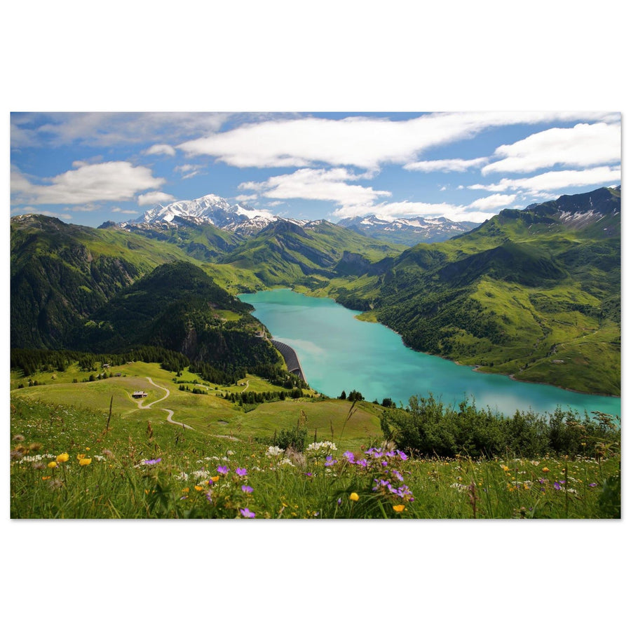
Header photo: Christophe Cappelli — Lake Roselend and Mont-Blanc from Roche Parstire.
The essentials in 30 seconds
- For a high view of the lake in its environment: Roche Parstire allows Roselend to be integrated into a much wider landscape.
- To work with the lake, roads, and alpine pastures: the Col du Pré and the roads in the area offer several intermediate readings.
- To give more weight to human elements: the shores, the dam, and the chapel change the scale of the scene.
- For another high view: the Grande Berge, from the Plan de la Lai sector, offers a distinct angle on the lake and the dam.
- To extend the outing: the Cormet de Roselend adds a landscape of a mountain pass and alpine pastures; the Roc du Vent remains a high-mountain context with its own access routes.
- Before leaving: check the actual opening of the roads, the condition of the routes, the weather, and any applicable drone restrictions.
Understanding the Roselend sector before choosing a viewpoint
Roselend combines elements that are sometimes wrongly opposed in mountain photography. The lake is in the middle of alpine pastures, but it is closed by a major hydroelectric structure. A road crosses the sector. The Sainte-Marie-Madeleine chapel was reassembled on the shore before the impoundment. Higher up, the ridges and passes reopen the landscape towards the Beaufortain and the Mont-Blanc massif.
This superposition is a photographic strength. It is not necessary to erase all human presence to obtain a coherent mountain image. The dam can become a geometric line. A road can create a curve. The chapel can give scale. Conversely, from a ridge, these same elements can become tiny, leaving more room for the shapes of the lake, the alpine pastures, and the relief.
The essential choice is therefore made even before shooting: do you want to show Roselend as a grand landscape, as a lake nestled in the alpine pastures, or as a territory where water, roads, and structures interact with the mountain? The answer determines the viewpoint much more than the abstract search for a "best spot."
Which viewpoint to choose depending on the desired image?
The following locations do not form a ranking. They correspond to different ways of constructing the image.
| Sector | What structures the image | Dominant reading | Engagement | If the scene doesn't work |
|---|---|---|---|---|
| Roche Parstire | Lake viewed from above, ridges, alpine pastures, and distant peaks | Expansive and layered | Official route from Col du Pré: 8.304 km and 640 m D+ on the sheet | Focus on the shape of the lake or a succession of relief features |
| Col du Pré and roads | Alpine pastures, roads, changes in slope, and openings to the relief | Closer to the terrain | Variable depending on the exact point; seasonal road access to be checked | Use the road as a secondary line or remove it from the frame |
| Shores, dam, and chapel | Water, structure, shore, and architectural elements | More graphic and closer | Depends on the chosen access and site conditions | Reduce the sky and work with water, dam, shore, and relief |
| Grande Berge / Plan de la Lai | High view of the lake and dam, alpine pastures, and relief | Panoramic from another axis | Official route: 7.4 km and 350 m D+ on the sheet | Isolate a portion of the shore, the dam, or multiple planes |
| Cormet de Roselend | Mountain pass, roads, alpine pastures, and high-altitude relief | Mountain pass landscape | Seasonal road access to be checked; pass at 1,968 m according to the Tourist Office | Let the pass become the subject if the lake no longer adds anything to the frame |
Roche Parstire: reading the lake from the ridge
Roche Parstire offers a high-angle view of Roselend. The official itinerary starts at Col du Pré, first crosses a wooded area, then reaches a much more open landscape before following the ridge. The lake appears below, while the Beaufortain, Mont-Blanc, and Pierra Menta enter the field of view depending on the orientation.
Photographically, the difficulty comes from the spectacular nature of the panorama. To the eye, the desire to include everything is strong. In the image, this can dilute the subject. The lake sometimes becomes a small blue shape among many masses of relief. Before widening further, ask yourself what truly carries the photograph.
If the shape of the lake is the priority, build the frame around it and let the alpine pastures or a slope provide a foreground. If Mont-Blanc or the distant peaks become more important, the lake may only be one reading element among several. A tighter framing can also transform the scene into a superposition of planes rather than a descriptive panorama.
Finally, the ridge allows the composition to evolve as you walk. The relative position of the lake, slopes, and summits changes with movement. This variation justifies taking the time to observe before choosing a definitive framing.
Col du Pré and roads: integrating human lines without losing the landscape
The Col du Pré, indicated at 1,700 m by the Tourist Office, is both a viewpoint and the starting point for the loop towards Roche Parstire. It primarily serves as a hinge between two ways of photographing Roselend: the reading from the roads and alpine pastures, and then the higher reading from the ridges.
In this intermediate register, human lines become more visible. A road can cross an alpine pasture, disappear behind a relief, then reappear further on. Used intentionally, it guides the eye and provides scale. Placed without hierarchy, it simply cuts the image.
The same reasoning applies to tracks and alpine chalets. They are not elements to be automatically removed. Their presence also tells a story of a pastoral territory. The challenge is to decide whether they structure the composition or become visual clutter.

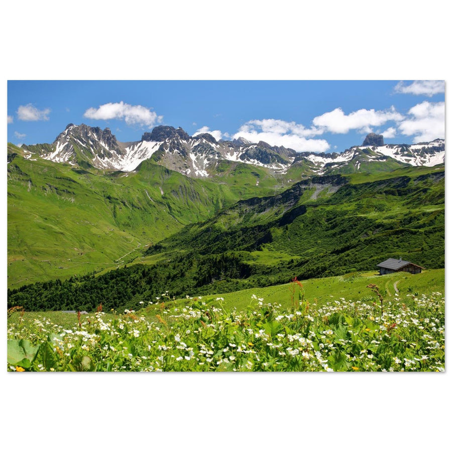
Roselend Valley in Beaufortain
This photograph shows the Roselend valley in a setting where the alpine pastures, paths, and relief take up more space than the lake itself.
Photograph: Denis Belitsky
Discover the Roselend Valley in Beaufortain printShores, dam, and chapel: changing scale
As you approach the lake and the dam, the image changes in nature. The large masses of the landscape remain present, but the constructed elements become significant enough to organize the frame. The dam can form a clear line. A shoreline can cut the water's surface. The Sainte-Marie-Madeleine chapel, reassembled on the shore before impoundment, introduces a smaller, more vertical architectural presence.
This proximity is particularly useful when the distant panorama lacks clarity. A uniform sky, partially obscured peaks, or a less spectacular light do not prevent working with the site's forms. The lake can become a colored background, the dam an axis, the shore a diagonal, and the chapel a scale point.
However, one must avoid trying to combine all these elements in the same photograph. A composition centered on the dam does not necessarily require adding the chapel. A shoreline image can work without showing the entire reservoir. The closer the viewpoint, the more important the selection of elements becomes.
Grande Berge and Plan de la Lai: another high-angle reading
Roche Parstire is not the only way to gain altitude around Roselend. The official Grande Berge itinerary starts in the Plan de la Lai sector and provides a view of the lake and dam, with Mont-Blanc, Outray, and Roc du Vent in the environment described by the Tourist Office.
The sheet indicates 7.4 km and 350 m D+. These figures are useful for comparing the effort with Roche Parstire, but they never replace checking actual conditions, trail status, and weather.
For the photographer, the main interest is the angle. Changing sides modifies how the dam, shores, and relief features overlap. This allows for constructing a series on Roselend without repeating the same high view. Choose this axis only if it provides an image truly different from what you have already obtained.
Cormet de Roselend and Roc du Vent: extending the reading of the sector
After the lake, the road continues towards the Cormet de Roselend, a pass located at 1,968 m according to the Tourist Office. The landscape opens onto alpine pastures and high-altitude relief before descending towards the Chapieux valley and the Tarentaise. This transition shows how the sector gradually moves from the large lake setting to that of the mountain pass.
It is not necessary for the lake to remain visible in every image. If the roads, alpine pastures, and relief become stronger, let them take over. The Cormet then serves as a coherent geographical extension, not a pretext to force Roselend to appear in the background of the frame.
The Roc du Vent also belongs to the visual identity of the sector. Official pages document views of Roselend, La Gittaz, the alpine pastures, and Mont-Blanc. But the via ferrata is a technical activity with its own equipment and approach march. It should not be presented as a common photo access.
Light and conditions: preparing two framings rather than a perfect time
Roselend does not have a "best time" that applies to all viewpoints. Light that works on a ridge can leave a shoreline in shadow. A clear sky can give depth to the peaks but make a dam composition very high contrast. Clouds, conversely, can simplify certain areas or completely obscure the distance.
The most robust preparation involves planning for two scales of framing. A wide view if the sky, lake, and relief work together. A tighter reading if the panorama loses its strength. At Roche Parstire, this might mean moving from a grand landscape to a portion of the lake. Near the dam, it might mean abandoning the peaks to work with the lines of the structure and the water.
The color of the lake should not become a promise either. Its photographic perception depends notably on light, viewing angle, sky, and image processing. Systematically trying to reproduce a spectacular hue often leads to neglecting the frame's structure.
Wide-angle, standard framing, or telephoto lens: simplifying the landscape
It is more useful to think in terms of framing families than mandatory focal lengths.
- Wide frame: relevant when the foreground has a real function. A slope, an alpine pasture, a shore, or a road can give direction to the image. Without a structure in the foreground, widening can simply reduce the lake and the peaks.
- Standard framing: useful when several elements need to remain legible without the foreground becoming dominant. It works well for the relationships between the lake, dam, alpine pastures, and relief.
- Telephoto lens: particularly useful from heights. It allows isolating a portion of Roselend, visually bringing several planes closer, or giving more weight to the dam and distant relief features. Its main function is not to "zoom in," but to eliminate what disperses the image.
Regardless of the framing, check the edges of the image. Roselend contains many strong elements; a poorly cut road, a piece of dam, or a shoreline unintentionally exiting the frame can weaken an otherwise solid composition.
Access, pastoralism, safety, and drone
Roselend remains a mountain area with seasonal road access. Official fact sheets indicate opening periods for the dam, Col du Pré, Cormet, and certain routes, but this information is subject to change. Before your outing, check the actual opening of roads, trail conditions, weather, and any local restrictions.
Roche Parstire and Grande Berge cross alpine pasture areas. Stay on marked trails, respect pastoral practices, and follow posted instructions. For rules concerning dogs, bivouacking, or other uses, check the specific itinerary rather than applying a general rule to the entire Beaufortain region.
For drones, the presence of aerial images in a gallery or online does not prove current authorization. Service-Public refers to the official map for checking restricted areas. The check must be done for the exact area and at the time of flight, also considering people, wildlife, and structures.
Practical sources to check before your outing
Mistakes that diminish Roselend's character
- Treating Roselend as a single panorama: the area changes scale between the ridge, roads, shores, and dam.
- Trying to show everything: a lake, Mont Blanc, a dam, a chapel, a road, alpine pastures, and several summits don't automatically become more interesting when they all fit into the same frame.
- Confusing lake color and composition: very colorful water attracts the eye, but doesn't replace a clear hierarchy of shapes.
- Applying a lighting recipe: a time that works from Roche Parstire doesn't become a rule for the banks or the Cormet.
- Multiplying movements without changing intention: if two viewpoints produce the same reading, deepening the first might be more useful than adding another stop.
- Transforming Roc du Vent into a generic photo access: views exist, but the via ferrata is a technical activity that should not be trivialized.
Frequently Asked Questions about Photography in Roselend
Which viewpoint should I choose to photograph Lake Roselend?
Roche Parstire is suitable for a high and very wide view of the lake in the Beaufortain. The areas around Col du Pré and the roads offer a closer view of the alpine pastures and terrain lines. The banks and the dam give more weight to the water and built elements. La Grande Berge offers another elevated axis. The right choice therefore depends on the desired image, not on a single ranking.
How do I get to Roche Parstire?
The official route presented by the Tourist Office starts from Col du Pré. The fact sheet indicates 8.304 km and 640 m elevation gain. These values describe the published route but do not replace checking the condition of the trail, the weather, and the conditions at the time of the outing.
Can I photograph Roselend without a long hike?
Yes. When seasonal roads are open, the dam, banks, chapel, and Col du Pré sectors already offer several framing scales. Roche Parstire or la Grande Berge primarily provide another elevated view and require a specific on-foot approach.
Is La Grande Berge worth visiting for photography?
It offers a different angle from Roche Parstire. The official fact sheet documents a view of Lake and Dam Roselend as well as several reliefs. Its photographic interest mainly depends on what you have already produced: if it doesn't truly change the reading of your series, there's no need to add this trip.
What is the best time to photograph Roselend?
There is no universally best time for the entire area. Light, shadows, and the readability of reliefs change depending on the viewpoint and conditions. Instead, prepare a wide composition and a more confined solution to be able to adapt the frame.
What focal length should I use in Roselend?
No focal length is mandatory. A wide frame works when the foreground structures the image. A standard framing balances several elements. A telephoto lens allows you to simplify the panorama and isolate portions of the lake, dam, or reliefs.
Can I use a drone at Lake Roselend?
No general authorization should be assumed. Check the exact area on official tools, temporary restrictions, and constraints related to people, wildlife, and structures before each flight.
Continue Exploring the Beaufortain
To place Roselend among the other landscapes of the massif, consult the guide: What to photograph in the Beaufortain? →
To discover the landscapes currently offered in the gallery, see Beaufortain photo prints on matte Dibond aluminum →