Mont-Blanc | Photographing Aiguille du Midi
Photography project · high altitude
At Aiguille du Midi, the difficulty is not finding a panorama: it is choosing a relationship simple enough to make altitude, void and the proximity of the summits immediately tangible.
The architecture clinging to the rock pinnacle, the ridges, silhouettes and the valley far below are measuring tools. Without them, the accumulation of peaks can flatten a landscape that is actually immense.
Decide whether your image is about the built site, the mass of Mont-Blanc, the fragility of a human presence or the depth down to Chamonix.
Central decision
What relationship best conveys the altitude?
Choose one main reference. The other layers should reinforce its measurement of the void, not become a collection of curiosities.
Walkways, terraces and built volumes reveal how narrow the rock is. Human lines make the slope and verticality immediately readable.
Establish a hierarchy between the dome, Mont-Blanc du Tacul and Mont Maudit instead of naming everything. Well-separated layers create more volume than an overly wide frame.
A tiny presence gives scale to the relief and tension to the frame. Remain an observer from authorised areas: the image never requires following someone onto mountaineering terrain.
The view towards Chamonix turns the slopes into successive layers. The high-altitude site should remain perceptible so the image does not become a simple aerial view.
Signature of the place
What distinguishes Aiguille du Midi from a generic panorama
The place creates a rare encounter between high mountains, accessible architecture and observation of Alpine practices.
Altitude removes familiar foregrounds. Separate the masses with light, a dark ridge or a strip of sky to preserve depth.
Built volumes cut the pinnacle and provide a fixed scale. They can become the main subject without reducing the power of the relief.
A body on bright snow or a dark ridge is enough to convey exposure. Wait for a clear separation and avoid overlapping several groups.
The contrast between the viewpoint and Chamonix far below creates a depth specific to the site. A slope diagonal helps connect those two worlds.

Buildings at the summit
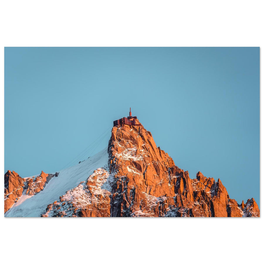
The station gives the pinnacle a sense of scale
The building and antenna remain small above the sunlit granite. Their regular geometry makes the size of the rock tangible, while the snow slope clearly separates the materials. Here, architecture contributes to the portrait of the site.
Photograph: Mumemories View the Aiguille du Midi station in the lightCompared positions
What the site's orientations change
Without leaving areas open to the public, changing terrace or orientation is enough to shift the hierarchy completely.

Evidence from the image
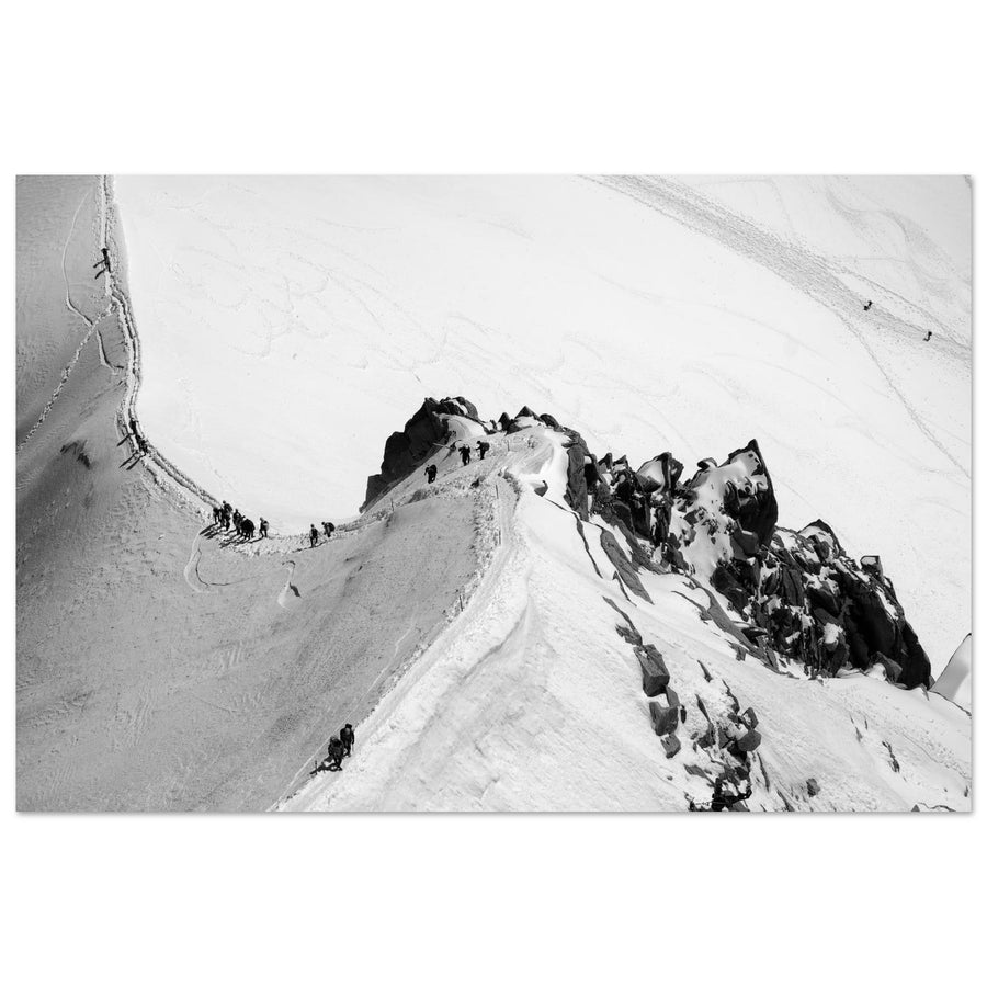
The silhouettes make the ridge and Mont-Blanc measurable
The mountaineers turn a succession of slopes into a scene of scale and exposure. Their smallness explains the mountain without requiring a wider panorama.
Photograph: Willem Cronje View this photograph of the Cosmiques ridgeThe subject of the image
When is the image still about Aiguille du Midi?
The image tells the story of Aiguille du Midi when the site, ridge or human relationship with altitude structures the composition. A simple horizon of summits is not enough to identify the place.
Architecture, pinnacle, silhouettes or plunging views provide a scale specific to the site and explain the relationship with the massif.
Every summit receives the same importance, no reference establishes scale and the location could be replaced by another high-altitude viewpoint.
The route, technical gestures and progression outside public areas carry the story. This composition guide is neither a route description nor permission to venture there.
Stay within the perimeter that matches your experience and the areas open to the public; a strong photograph of the site never requires crossing a safety boundary.
Useful failures
What makes the image fail and what to change
At this altitude, the backup must protect both the readability of the frame and your physical ability to continue.
Move from panorama to architecture
Windows, tunnels, rock and nearby silhouettes remain readable. Use clouds as negative space instead of waiting for a summit that does not appear.
Build an image of masses
Protect highlights in the snow and look for a dark ridge or silhouette. Shadow detail can give way to clear geometry.
Reduce the number of elements
Wait for separation, change orientation or frame a single opening. Crowds are most distracting when they have no scale function.
Stop the project
Do not turn a photographic objective into an obligation. Follow on-site instructions, move to a sheltered area or descend if necessary.
Real terrain
Prepare an outing to Aiguille du Midi
Opening, schedules, booking, wind and visibility can alter or interrupt access. Check with the operator on the day and keep a margin for the descent.
Altitude is felt even on a developed site. Dress for cold and solar radiation, move calmly, protect your equipment and follow instructions. Any outing beyond public areas is a high-mountain practice requiring its own skills, equipment and preparation.
Check before the outing
Check the factors governing access, comfort and safety.
- opening, schedules, possible booking and last descent;
- wind, temperature, visibility, snow and weather evolution;
- clothing, sun protection, batteries and means of keeping equipment dry;
- physical condition, effects of altitude and limits of accessible areas.
Official sources
Check access with the operator and mountain conditions with local organisations.
Continue the project
Find another scale of the massif
Useful neighbouring guides
Descend towards a glacier or inhabited landscape to change the relationship without leaving the massif.
Return to choosing the territory
Compare high-altitude, valley and glacier projects with external viewpoints.
Explore other views of Aiguille du Midi
The dedicated collection lets you compare the pinnacle, buildings and high-mountain scenes through other works depicting the same site.