Où photographier le col Agnel, le Pain de Sucre et le haut Queyras ? - AluArtMountains

Where to photograph the Agnel Pass, Pain de Sucre, and Haut Queyras?

Published on July 30, 2026

The Col Agnel, the Refuge Agnel, and the Pain de Sucre embody the highest and most cross-border identity of the Queyras region. The road ascends the Aigue Agnelle valley to the Italian border, traversing increasingly open alpine pastures and culminating amidst landscapes where lines become simple: a road, a refuge, a ridge, and the massive silhouette of the Pain de Sucre.

This area can be photographed without extensive hiking from the road and high-altitude car parks, but it also allows for much more extensive exploration. From around the refuge, compositions combine man-made structures with high mountains. At the pass, the view shifts towards the Varaita Valley and Mont Viso. Ascending the Pain de Sucre offers another level of interpretation, but it should not be underestimated due to its short distance: the exposed sections, slabs, and short final climb make the route challenging.

This guide explains how to build a coherent series from the valley, the refuge, the pass, and the summit, by choosing the right light, appropriate focal lengths, and a realistic level of commitment. It complements our general guide to the Queyras, as well as the guides on Col d'Izoard and Casse Déserte, Ceillac and its lakes, and Saint-Véran and the Clausis chapel.

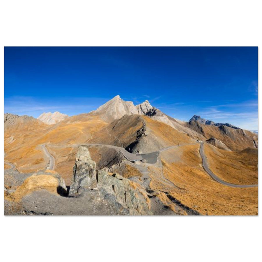
Photo print of Col Agnel and Pain de Sucre in autumn in the Queyras
In autumn, the hues of the alpine pastures highlight the road and the shape of the Pain de Sucre in the upper Queyras. Photography by Francois Roux. Discover this photo print of Col Agnel.

The essentials in 30 seconds

  • Most accessible subject: Col Agnel and the high-altitude road, with possible compositions in the immediate vicinity of parking areas when the road is open.
  • Most narrative subject: Refuge Agnel facing the Pain de Sucre, which provides a human scale to the landscape.
  • Best versatile focal length: a 24–70 mm for the road, the refuge, and border views; a 70–200 mm to simplify ridges and bring Mont Viso closer.
  • Best colorful season: autumn, before the winter road closure and provided safe conditions.
  • Ascension of Pain de Sucre: short distance route but officially classified as very difficult, with exposed sections, slabs, and a short climb.
  • Essential tip: it's not necessary to reach the summit to create a strong series. The pass, the refuge, and the curves of the road are already enough to tell the story of the upper Queyras.

Why photograph Col Agnel and Pain de Sucre?

Col Agnel is located at an altitude of 2,744 meters, at the end of the Aigue Agnelle valley. It connects the Queyras to the Italian Val Varaita and is surrounded by very distinct reliefs: the Pain de Sucre, the Taillante ridge, Pic d'Asti and, beyond the border, Mont Viso. This arrangement provides the photographer with several naturally hierarchical planes, without the need to artificially add elements to the frame.

The first strength of the area is its progression. As you ascend from Molines-en-Queyras and Fontgillarde, the landscape gradually leaves behind hamlets and larches to open up into more vast alpine pastures. Refuge Agnel then appears as the last significant building before the pass. Higher up, constructions almost entirely disappear, and the road becomes one of the main graphic lines.

The second strength lies in the border. The pass doesn't just offer a view towards a neighboring slope: it separates two valleys whose shapes, lights, and cloud masses can differ. A dull light on the French side can sometimes reveal an opening towards Italy, or vice versa. This shift adds depth to the images and allows for the construction of compositions that suggest passage rather than just an isolated summit.

Finally, the Pain de Sucre provides an instantly recognizable silhouette. Photographed from the refuge or the road, it dominates the frame without requiring an ascent. From its slopes and summit, the subject, on the contrary, becomes the panorama itself: border ridges, French and Italian valleys, Mont Viso, and a succession of reliefs. The two approaches are complementary but do not require the same equipment or the same level of preparation.

Pass, refuge or summit: which sector to choose?

Sector Main subjects Useful light Focal lengths Watch point
Aigue Agnelle Valley Road, torrent, alpine pastures, relief curves, progression towards the pass Morning, late afternoon, autumn 24–200 mm Avoid photographing the road as a mere track without an endpoint
Refuge Agnel Refuge, Pain de Sucre, residual snow, human presence Side light or overcast sky 35–135 mm Respect guests, guardians, and refuge activity
Col Agnel Border, road, signs, Val Varaita, Mont Viso, ridges Sunrise, late afternoon, contrasting weather 24–200 mm Wind, traffic, altitude, and rapid weather changes
Slopes of Pain de Sucre Summit, mineral, hikers, plunging views Morning or side light 24–135 mm Steep terrain, exposed passages, and rockfalls
Summit of Pain de Sucre Mont Viso, Queyras, Italy, panoramas and ridges Stable visibility and moderate wind 24–200 mm Do not sacrifice safety to wait for late light

For a first outing, the refuge-pass duo offers the best balance between variety, accessibility, and time devoted to each image. The summit should be considered a mountain project in its own right, not just an extension of the photo session.

Access and organization of the outing

Col Agnel is reached by the departmental road that ascends from Molines-en-Queyras, Pierre-Grosse, and Fontgillarde. This high-altitude road is not cleared of snow in winter, and its opening varies depending on snow cover, rockfalls, works, and weather conditions. Before any departure, consult the actual status of the pass on the Info Route 05 service rather than relying on a usual opening date.

When the road is open, several areas allow stopping around the refuge and towards the pass. The official starting point for the Pain de Sucre is in a car park located approximately 300 meters after the refuge when climbing towards the pass. Parking must never encroach on the roadway, obstruct emergency services, or block access to the refuge.

The pass is directly accessible by car, bike, or on foot depending on the season. This ease can give a false sense of security. At 2,744 meters, wind, cold, and storms can rapidly change conditions, even if the car remains nearby. A sunset session also requires anticipating the return, the drop in temperature, and potential traffic on a narrow road.

For the Pain de Sucre, the official itinerary is announced as approximately 5.8 kilometers round trip and 533 meters of elevation gain, with an estimated duration of 3 h 30. It is classified as very difficult. The low elevation gain should not obscure the exposed sections, potentially slippery slabs, the short final climb, and the risks of rockfalls. In the presence of snow, ice, or strong wind, the commitment significantly increases.

To remember: always separate the photographic program from the sporting program. If the main objective is the light at the pass or the refuge, do not automatically plan the summit on the same day. If the objective is the Pain de Sucre, set a turnaround time and accept to forgo late light.

Photographing the Aigue Agnelle Valley

The Aigue Agnelle valley is often traversed too quickly to reach the pass. Yet, it constitutes the logical beginning of a photographic series. Hamlets and larches first provide a familiar scale, then trees become scarcer, slopes become more open, and the Pain de Sucre gradually gains prominence.

The road can serve as a leading line, provided it has a clear destination. A turn without context can easily produce a decorative but hard-to-read image. Instead, look for a curve that leads towards the Pain de Sucre, a ridge, or a well-lit area. A telephoto lens is often more effective than a very wide-angle lens: it compresses planes, reduces the sky, and makes the relationship between the road and the summit more visible.

The stream, wet areas, and variations in the colors of the alpine pastures can complete the narrative, but they should not all appear in the same image. Choose a dominant idea: the road towards the border, the transition from larches to high-altitude meadows, or the size of the summit relative to a car or cyclist. A discreet human silhouette can give scale without turning the landscape into a sports photograph.

In autumn, the palette becomes more nuanced. Golden larches are mainly present in the lower part, while the alpine pastures take on ochre and brown tones around the refuge and the pass. This colorful progression works particularly well in a series of three or four images taken at different altitudes.

Photographing Refuge Agnel facing Pain de Sucre

Refuge Agnel is one of the best visual landmarks in the area. Located at the foot of the reliefs, it allows for an immediate sense of the scale of Pain de Sucre. However, a photograph solely focused on the building risks losing the identity of the upper Queyras. It's better to leave enough space around the refuge to show its relationship with the slope, the road, and the summit.

Using the refuge as a point of scale

At 35 or 50 mm, place the refuge in the lower third of the frame and let the Pain de Sucre occupy the upper plane. Avoid placing the building too close to the edge of the image. A section of ground in front of it facilitates reading and gives a sense of distance. With a 70–200 mm lens, compression visually brings the refuge closer to the summit and produces a more graphic image.

Working with snow

Residual snow simplifies shapes and makes the building stand out, but it requires precise exposure. Monitor the histogram and protect the highlights without excessively underexposing the shadows of the refuge. In cold light, a slightly more neutral white balance helps maintain the ambiance without making the snow artificially blue.

Respecting the functioning of the place

The refuge remains an accommodation and a workplace. Do not block access with a tripod, do not photograph people up close without their consent, and avoid framing that gives the impression of an abandoned building when it is active. If you use the terrace as a foreground, ask for permission when it inconveniences guests or staff.

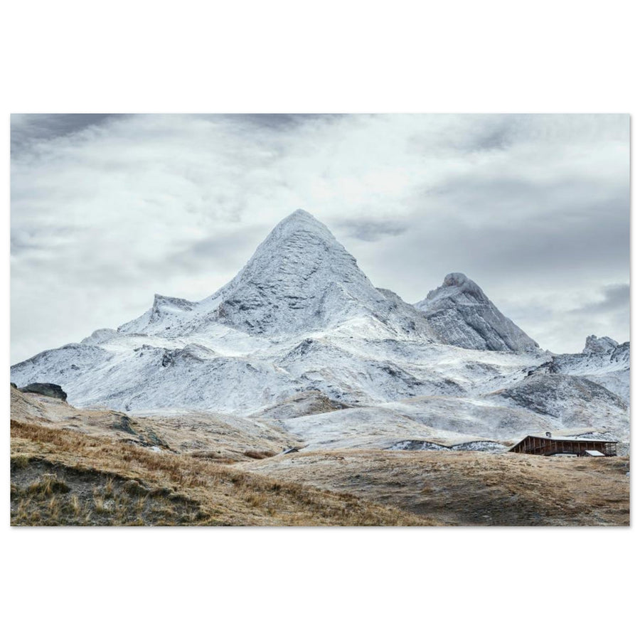
Photo print of Refuge Agnel facing snow-covered Pain de Sucre in the Queyras
The refuge provides a human scale to Pain de Sucre and highlights the isolation of the upper Queyras. Photography by G.Barattini-Photography. View this photo print of Refuge Agnel.

Photographing Col Agnel and the Italian border

At the pass, the landscape changes logic. The road ceases to be merely a means of access and becomes a central element of composition. Signs, markers, and traces of traffic indicate the passage between the two countries, while the Val Varaita opens up on the Italian side. Mont Viso can dominate the background when visibility is good.

Telling the story of the passage rather than the sign

A frontal shot of the pass sign remains documentary. To create a stronger image, integrate the sign or marker as a secondary element, then use the road, a ridge, or a succession of planes to guide the eye. The place should remain identifiable without the entire photograph depending on legible text.

Using Mont Viso without overwhelming the landscape

Mont Viso naturally draws attention, but its prominence depends on the focal length. With a wide-angle, it can seem distant and lose its impact. A 70–200 mm lens brings it closer to the pass and simplifies intermediate reliefs. However, keep an element of the French or border foreground so that the image tells the story of the viewpoint and not just the Italian summit.

Composing with Traffic

The road remains open to vehicles when the pass is accessible. Only set up in a safe area, without a tripod on the road or walking backward around a bend. A vehicle or cyclist can serve as a scale reference, but should never be provoked or directed from the road. Days when the pass is reserved for bicycles also change photographic opportunities: check for events and temporary closures.

Photographing Pain de Sucre

The Pain de Sucre can be treated in three ways: as a silhouette from the valley, as a dominant mass from the refuge and the pass, or as mountain terrain during the ascent. The first approach is the most accessible and often the most graphic. The second shows textures and slopes. The third adds engagement, hikers, and views towards other peaks.

From the Road and the Refuge

The summit has a compact shape that lends itself well to minimalist compositions. Look for a road, a snowfield, or an alpine curve that follows its direction. In flat light, a telephoto lens can isolate mineral strata and avoid an overly uniform sky. In side light, a 35–70 mm is often enough to keep both the mountain and its context.

From the Trail

During the climb, the interest comes from changes in angle. The summit first appears massive, then the slopes and slabs become more visible. Hikers can provide scale, but keep enough distance to avoid confining them against the edge of the frame. On steep sections, put away your camera when your hands are needed: photography should not compromise secure footing.

From High Points

As the altitude increases, the view expands towards Queyras and Italy. The risk is producing a panorama without hierarchy. Use ridges as successive layers and choose a main subject: Mont Viso, the pass road, Val Varaita, or the Queyras relief. Panoramic assemblies are only relevant if the wind allows stable framing and if the foreground does not change between shots.

Do you need to reach the summit for successful images?

No. The summit of Pain de Sucre offers a remarkable panorama, but it is not necessary to tell the story of the area. From the refuge and the pass, Pain de Sucre remains visible as the main subject, the road provides strong lines, and Mont Viso is already visible from the border. These viewpoints also allow you to wait for late light while remaining close to an easy return.

The ascent becomes relevant when the photographic project focuses on the ridges, the passage between valleys, or the high-mountain experience. In this case, the choice of light must be compatible with safety. Climbing for sunrise or descending after sunset increases difficulties with orientation, cold, and progress on exposed sections. This strategy is only suitable for experienced, equipped, and fully informed individuals.

The summit also does not guarantee better photography. A very wide view may lack structure, while a lower composition combining the refuge, the road, and Pain de Sucre often tells more about the place. Before climbing, define precisely what altitude should add to your series.

Sunrise, sunset, clouds, and wind: what light to choose?

In the Morning

The morning often offers a calmer atmosphere and reduced traffic. The light can gradually reveal border reliefs and facilitate an ascent to Pain de Sucre with ample time. It is well suited for rock details, snowfields, and images that contrast shadow and light.

Late Afternoon

Late afternoon warms the alpine pastures and enhances autumn colors. It works particularly well for the refuge, the road, and views from the pass. The main risk is extending the session too late as the temperature drops and the return becomes more difficult. Keep a margin before night, especially if you are moving away from the vehicle.

Clouds and Border Mists

The pass can be caught in cloud masses rising from one side while the other remains clear. These situations create very graphic separations, but they can also eliminate all visibility in a few minutes. Work with medium focal lengths to isolate openings, without committing to a summit when the evolution becomes uncertain.

Wind

Wind is frequent on ridges and can make a tripod useless or dangerous. Lower the sections, remove the flapping strap, slightly increase the shutter speed, and stabilize the camera with your body. On a ridge or near the road, prefer handheld shooting over deployed equipment in an exposed area.

Which season to choose?

Early Summer: Residual Snow and Contrast

After the road reopens, snowfields can still structure the slopes. The refuge, Pain de Sucre, and the ridges gain in contrast, but the trails may remain wet, snowy, or unstable. Check conditions before any ascent and do not deduce the terrain's state solely from the pass's opening.

Summer: Easiest Access

Summer generally offers the best road accessibility and the longest daylight hours. The alpine pastures are greener, the refuge is active, and the area can be frequented by cyclists and hikers. To reduce human presence, start early and focus on long focal lengths rather than waiting for a totally empty landscape.

Autumn: Low Colors and First Snow

Autumn is the season most consistent with the main product in the catalog. The alpine pastures take on ocher tones, larches color the lower part of the valley, and a first snow can highlight Pain de Sucre. The trade-off is more changeable weather and a possible earlier closure of the pass than expected.

Winter: A Completely Different Project

In winter, the pass road is not cleared of snow. Access becomes a mountain outing on skis or snowshoes, depending on the routes, with avalanche risk management and adapted autonomy. The refuge may have a winter guardianship period, but dates change. This guide is primarily designed for the road season; a winter session must be prepared with snow and avalanche bulletins, refuge information, and, if necessary, a professional.

Eight compositions and suitable focal lengths

1. The Road to Pain de Sucre

Use a curve as a leading line and place the summit above its vanishing point. A 50–100 mm lens prevents the mountain from appearing too small.

2. The Refuge Below the Summit

Frame with a 70–135 mm lens to bring the refuge and Pain de Sucre closer. Leave a strip of foreground to avoid crushing the building against the bottom edge.

3. The Pass as a Border Crossing

Combine a marker, a sign, or the roadway with Val Varaita. A 24–70 mm lens allows you to keep the context without making the sign the sole subject.

4. Mont Viso with a Telephoto Lens

At 100–200 mm, bring Mont Viso closer to the ridges of the pass. Integrate a road line or a Queyras slope to situate the viewpoint.

5. Layers of Relief from the Slopes

Superimpose three or four ridges using a long focal length. Wait until a difference in light or mist sufficiently separates each plane.

6. A Hiker as Scale

Place the silhouette on a clear slope, with enough space in the direction of travel. A fast shutter speed avoids unintentional blur when wind and terrain make framing unstable.

7. Snow and Rock in Minimalist Composition

Isolate a diagonal snowfield and a portion of ridge with a 70–200 mm lens. This approach works when the sky is uniform and the wide view lacks depth.

8. A Progression Series

Photograph successively the valley, the refuge, the pass, then the summit. Maintain consistency in format and processing to tell the story of the altitude rather than juxtaposing four independent images.

Three photo outing strategies

Option 1 — Refuge and pass without ascent

Start from the valley in the late afternoon, photograph the refuge when the light becomes lateral, then climb to the pass for views towards Italy. This option maximizes variety while ensuring an easy return. It is suitable for initial reconnaissance and uncertain weather conditions.

Option 2 — Pain de Sucre as the main objective

Depart early from the parking lot above the refuge, with stable weather and light equipment. Photograph the progress, but do not make too many stops in technical sections. At the summit or a safe high point, choose a single main axis before descending with ample time.

Option 3 — Autumn and the valley story

Build a series from the hamlets and larches up to the alpine pastures of the pass. Use changes in color and vegetation as a guiding thread. Pain de Sucre remains present in several images, but its size gradually increases with altitude.

Equipment and Settings

Simple and robust equipment is preferable to an overly heavy bag, especially if you plan to climb Pain de Sucre.

  • 24–70 mm: main lens for the valley, refuge, road, and pass.
  • 70–200 mm: useful for Mont Viso, ridges, textures, and refuge-summit compression.
  • Ultra wide-angle: to be reserved for situations where a strong foreground justifies widening the frame.
  • Tripod: useful at the pass and near the refuge in light wind; often cumbersome or unsuitable on steep sections.
  • Polarizing filter: can enhance certain colors and reduce glare, but its effect becomes irregular with a wide-angle lens under a very clear sky.
  • External battery: the refuge states that it operates on its own power supply and does not charge visitors' devices.

Initial Settings

  • Handheld landscape: ISO 100 to 400, f/7.1 to f/11, shutter speed adapted to wind and focal length.
  • Telephoto lens: prioritize a speed of at least 1/500 s when there is wind or a moving subject.
  • Snow: check the histogram and apply a positive correction only if the whites become gray without being blown out.
  • Panorama: manual exposure and white balance, consistent overlap, and stable horizon.
  • Blue hour: use a tripod only in a safe area, off the road, and away from traffic.

To delve deeper into these choices, consult our guide on mountain photography settings.

Safety, dogs, drones, and respect for the site

Col Agnel and Pain de Sucre are located in high mountains. Consult the weather, road conditions, and, in snowy conditions, the avalanche risk assessment bulletin. Bring warm clothes, water, sun protection, a lamp, and sufficient battery. The phone network should not be considered guaranteed throughout the route.

Pain de Sucre is classified as very difficult by the Tourist Office despite its short distance. Exposed sections, slabs, minor climbing, and rockfalls require keeping hands free and putting away the camera when the terrain demands it. In spring and autumn, ice can persist even when the trail appears dry lower down.

In the Queyras Regional Natural Park, dogs must be kept on a leash in alpine pastures, forests subject to forest regulations, and near herds. The official Pain de Sucre itinerary also mentions dogs on a leash. Avoid herds and do not approach guard dogs to get a picture.

Drone use is highly regulated. In the communes of the Park, recreational takeoff, piloting, and landing from public land are prohibited within 200 meters of wildlife, refuges, lakes, huts, alpine chalets, livestock, and guard dogs. The presence of the Agnel refuge and high-altitude wildlife therefore significantly reduces possibilities. Consult the Molines-en-Queyras decree, the official aerial map, and European regulations before any project.

Finally, stay on existing paths, do not move stones, and do not trample high-altitude flora to create a foreground. Successful mountain photography does not justify degrading the site or endangering oneself.

Photo prints of Col Agnel and Pain de Sucre

The two works available in the gallery show the two main interpretations of the area: the pass and its alpine pastures in autumn, then the refuge facing the snow-covered summit. They are offered as photo prints on matte Dibond aluminum, made to order. The medium limits reflections and offers excellent flatness, suitable for road lines, mineral textures, and nuances of snow.

Col Agnel and Pain de Sucre in autumn

The photograph by Francois Roux highlights the warm tones of the alpine pastures, the road, and the silhouette of Pain de Sucre.

View the photo print of Col Agnel and Pain de Sucre

Agnel refuge facing snow-covered Pain de Sucre

The photograph by G.Barattini-Photography uses the refuge as a scale point beneath the snow-covered slopes.

View the photo print of Agnel refuge

Explore the collection

Discover all Queyras photo prints

FAQ — Col Agnel and Pain de Sucre

What is the best time to photograph Col Agnel?

Summer generally offers the easiest road access, while autumn brings ocher alpine pastures and sometimes the first snow on the reliefs. However, the opening of the pass depends on snow cover and weather: always check Info Route 05 before departure.

Is the Col Agnel road open all year round?

No. The high-altitude road is not cleared of snow during the winter and may close due to snow or unfavorable conditions. Usual dates do not replace official daily information.

Can you take good photos without climbing Pain de Sucre?

Yes. The refuge, the road, and the pass already offer strong views of Pain de Sucre, Val Varaita, and Mont Viso. They also allow you to work longer at sunrise or sunset without undertaking a technical descent.

What is the difficulty of climbing Pain de Sucre?

The official route is classified as very difficult. It is approximately 5.8 kilometers round trip and 533 meters of elevation gain, with exposed sections, potentially slippery slabs, and minor climbing. Snow, ice, and wind conditions can further increase the difficulty.

What is the best time of day to photograph the area?

The morning is suitable for an ascent and often offers a calmer atmosphere. Late afternoon warms the alpine pastures and is very well suited for the refuge and the pass. The choice mainly depends on the weather, wind, and the margin needed for the return.

What focal length to use at Col Agnel?

A 24–70 mm lens covers most compositions with the road, the refuge, and the border. A 70–200 mm lens is particularly useful for bringing Mont Viso closer, isolating ridges, and compressing the refuge under Pain de Sucre.

Are dogs allowed on the Pain de Sucre trail?

The official itinerary allows them provided they are kept on a leash. More broadly, Park regulations require dogs to be leashed in alpine pastures, forests under forest management, and near herds. Check local regulations before your outing.

Can I use a drone around Col Agnel and the refuge?

Usage is highly restricted. Park regulations notably prohibit recreational takeoff, piloting, and landing from public land within 200 meters of refuges, wildlife, livestock, and several other sensitive areas. Consult the Molines-en-Queyras municipal decree and official aerial restrictions.

Back to blog